Bagaha geodata
Bagaha (Bihar) is a populated place; located in India in Asia/Kolkata (GMT+5.5) time zone. With population of 103,855 people, there are 420 cities with bigger population in this country. Compared to other cities in India, 79.2% of cities are located further ↓South; 82.2% of cities are located further ←West and 69.7% of cities have higher elevation than Bagaha. Note1


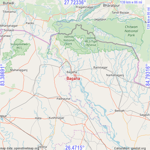
Bagaha GPS coordinates[2]
27° 5' 57.048" North, 84° 5' 24.108" East
| Map corner | latitude | longitude |
|---|---|---|
| Upper-left | 27.72336°, | 83.38691° |
| Center: | 27.09918°, | 84.09003° |
| Lower-right: | 26.4715°, | 84.79316° |
| Map W x H: | 139.2×139.2 km | = 86.5×86.5mi |
| max Lat: | 34.9274° ⇑20.8% North |
| Bagaha: | 27.09918° |
| min Lat: | ⇓79.2% South 8.09008° |
| min Long | Bagaha | max Long |
| 68.82655° | 84.09003° | 96.81° |
| W 82.2%⇐ | ⇒17.8% E |
Elevation
Elevation of Bagaha is 94 m = 308 ft, and this is 201.6 m = 661 ft below average elevation for this country.
| Max E: |
3681 m = 12077 ft | 69.7% |
| Avg. | 295.6 m = 970 ft | |
| Bagaha | 94 m = 308 ft | |
Min E: |
1 m = 3 ft | 30.3% |
See also: Bagaha elevation on elevation.city.
Geographical zone
Bagaha is located in North temperate zone (between Tropic of Cancer and the Arctic Circle). Distance of this Northern Tropic circle is 407.2 km =253 mi to South.| Distance of | km | miles | from Bagaha |
|---|---|---|---|
| North Pole | 6993.9 | 4345.8 | to North |
| Arctic Circle | 4388 | 2726.6 | to North |
| Tropic Cancer | 407.2 | 253 | to South |
| Equator | 3013.1 | 1872.3 | to South |


Nearby cities:
15 places around Bagaha: (largest is in red/bold)
• Bettiah
52.6 km =32.7 mi,  128°
128°
• Captainganj
42 km =26.1 mi,  242°
242°
• Deoria
73.2 km =45.5 mi,  204°
204°
• Hātā
52.5 km =32.6 mi,  220°
220°
• Khada
22.5 km =14 mi,  294°
294°
• Mahārāganj
52.5 km =32.6 mi,  275°
275°
• Nautanwa
75.8 km =47.1 mi,  298°
298°
• Nichlaul
43.2 km =26.8 mi, 303°
• Padrauna
24.2 km =15 mi,  206°
206°
• Pipraich
63.5 km =39.5 mi, 241°
• Raxaul
76.5 km =47.5 mi,  99°
99°
• Rāmkola
33.3 km =20.7 mi,  228°
228°
• Rāmnagar
24.2 km =15 mi,  72°
72°
• Sagauli
74.7 km =46.4 mi,  119°
119°
• Siswā Bāzār
33.3 km =20.7 mi, 279°
Sources, notices
• [Note1] Compared only with cities in India existing in our database
• [Src1] Map data: © OpenStreetMap contributors (CC-BY-SA)
• [Src2] Other city data from geonames.org with taken over terms of usage.
• [Src3] Geographical zone / Annual Mean Temperature by Robert A. Rohde @ Wikipedia
