Pachperwa geodata
Pachperwa (Uttar Pradesh) is a populated place; located in India in Asia/Kolkata (GMT+5.5) time zone. With population of 15,056 people, there are 2458 cities with bigger population in this country. Compared to other cities in India, 82% of cities are located further ↓South; 78.4% of cities are located further ←West and 66.7% of cities have higher elevation than Pachperwa. Note1


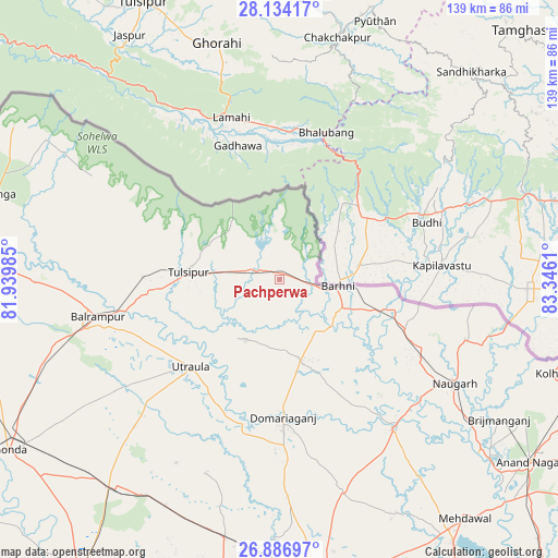
Pachperwa GPS coordinates[2]
27° 30' 44.424" North, 82° 38' 34.692" East
| Map corner | latitude | longitude |
|---|---|---|
| Upper-left | 28.13417°, | 81.93985° |
| Center: | 27.51234°, | 82.64297° |
| Lower-right: | 26.88697°, | 83.3461° |
| Map W x H: | 138.7×138.7 km | = 86.2×86.2mi |
| max Lat: | 34.9274° ⇑18% North |
| Pachperwa: | 27.51234° |
| min Lat: | ⇓82% South 8.09008° |
| min Long | Pachperwa | max Long |
| 68.82655° | 82.64297° | 96.81° |
| W 78.4%⇐ | ⇒21.6% E |
Elevation
Elevation of Pachperwa is 108 m = 354 ft, and this is 187.6 m = 615 ft below average elevation for this country.
| Max E: |
3681 m = 12077 ft | 66.7% |
| Avg. | 295.6 m = 970 ft | |
| Pachperwa | 108 m = 354 ft | |
Min E: |
1 m = 3 ft | 33.3% |
See also: India elevation on elevation.city.
Geographical zone
Pachperwa is located in North temperate zone (between Tropic of Cancer and the Arctic Circle). Distance of this Northern Tropic circle is 453.2 km =281.6 mi to South.| Distance of | km | miles | from Pachperwa |
|---|---|---|---|
| North Pole | 6948 | 4317.3 | to North |
| Arctic Circle | 4342.1 | 2698.1 | to North |
| Tropic Cancer | 453.2 | 281.6 | to South |
| Equator | 3059.1 | 1900.8 | to South |


Nearby cities:
15 places around Pachperwa: (largest is in red/bold)
• Anandnagar
77.2 km =48 mi,  126°
126°
• Balrāmpur
46.1 km =28.6 mi,  258°
258°
• Bastī
80.8 km =50.2 mi,  174°
174°
• Bhinga
73 km =45.4 mi,  286°
286°
• Bānsi
47.1 km =29.3 mi,  142°
142°
• Gondā City
80.2 km =49.8 mi,  238°
238°
• Haraiya
81.7 km =50.8 mi,  192°
192°
• Ikauna
66.5 km =41.3 mi,  271°
271°
• Katra
60.8 km =37.8 mi, 269°
• Khargupur
66.4 km =41.3 mi, 256°
• Mankāpur
65.5 km =40.7 mi,  218°
218°
• Mehndāwal
75.4 km =46.9 mi, 142°
• Nautanwa
77 km =47.8 mi,  97°
97°
• Tulsīpur
22.5 km =14 mi,  276°
276°
• Utraula
30.8 km =19.1 mi,  225°
225°
Sources, notices
• [Note1] Compared only with cities in India existing in our database
• [Src1] Map data: © OpenStreetMap contributors (CC-BY-SA)
• [Src2] Other city data from geonames.org with taken over terms of usage.
• [Src3] Geographical zone / Annual Mean Temperature by Robert A. Rohde @ Wikipedia
