Srīnagar geodata
Srīnagar (Uttarakhand) is a populated place; located in India in Asia/Kolkata (GMT+5.5) time zone. With population of 20,216 people, there are 2021 cities with bigger population in this country. Compared to other cities in India, 93.5% of cities are located further ↓South; 56.7% of cities are located further ←West and 85.3% of cities have lower elevation than Srīnagar. Note1


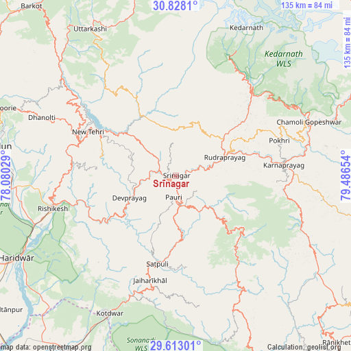
Srīnagar GPS coordinates[2]
30° 13' 20.748" North, 78° 47' 0.276" East
| Map corner | latitude | longitude |
|---|---|---|
| Upper-left | 30.8281°, | 78.08029° |
| Center: | 30.22243°, | 78.78341° |
| Lower-right: | 29.61301°, | 79.48654° |
| Map W x H: | 135.1×135.1 km | = 83.9×83.9mi |
| max Lat: | 34.9274° ⇑6.5% North |
| Srīnagar: | 30.22243° |
| min Lat: | ⇓93.5% South 8.09008° |
| min Long | Srīnagar | max Long |
| 68.82655° | 78.78341° | 96.81° |
| W 56.7%⇐ | ⇒43.3% E |
Elevation
Elevation of Srīnagar is 554 m = 1818 ft, and this is 258.4 m = 848 ft above average elevation for this country.
| Max E: |
3681 m = 12077 ft | 14.7% |
| Srīnagar | 554 m 1818 ft | |
| Avg. | 295.6 m = 970 ft | |
Min E: |
1 m = 3 ft | 85.3% |
See also: India elevation on elevation.city.
Geographical zone
Srīnagar is located in North temperate zone (between Tropic of Cancer and the Arctic Circle). Distance of this Northern Tropic circle is 754.5 km =468.8 mi to South.| Distance of | km | miles | from Srīnagar |
|---|---|---|---|
| North Pole | 6646.6 | 4130 | to North |
| Arctic Circle | 4040.8 | 2510.8 | to North |
| Tropic Cancer | 754.5 | 468.8 | to South |
| Equator | 3360.4 | 2088.1 | to South |


Nearby cities:
15 places around Srīnagar: (largest is in red/bold)
• Birbhaddar
51.1 km =31.8 mi,  250°
250°
• Devaprayāg
19.3 km =12 mi,  243°
243°
• Doiwāla
64.3 km =40 mi,  265°
265°
• Dugadda
49.1 km =30.5 mi,  199°
199°
• Kedārnāth
61.7 km =38.3 mi,  26°
26°
• Kotdwāra
58.6 km =36.4 mi,  205°
205°
• Lansdowne
43.5 km =27 mi,  193°
193°
• Narendranagar
48.2 km =30 mi,  261°
261°
• Pauri
7.8 km =4.8 mi,  184°
184°
• Pīpalkoti
66.1 km =41.1 mi,  70°
70°
• Rishīkesh
48.9 km =30.4 mi, 254°
• Rudraprayāg
20.4 km =12.7 mi, 70°
• Rāīwāla Bara
57.9 km =36 mi, 246°
• Tehri
34.6 km =21.5 mi,  302°
302°
• Uttarkāshi
65.2 km =40.5 mi,  329°
329°
Sources, notices
• [Note1] Compared only with cities in India existing in our database
• [Src1] Map data: © OpenStreetMap contributors (CC-BY-SA)
• [Src2] Other city data from geonames.org with taken over terms of usage.
• [Src3] Geographical zone / Annual Mean Temperature by Robert A. Rohde @ Wikipedia
