Naraura geodata
Naraura (Uttar Pradesh) is a populated place; located in India in Asia/Kolkata (GMT+5.5) time zone. With population of 22,432 people, there are 1881 cities with bigger population in this country. Compared to other cities in India, 85.3% of cities are located further ↓South; 52.9% of cities are located further ←West and 53.5% of cities have higher elevation than Naraura. Note1


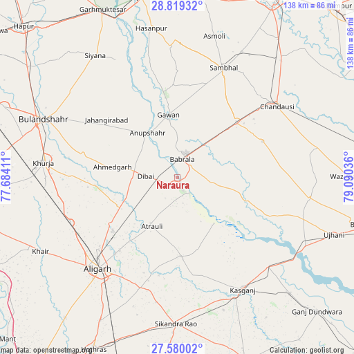
Naraura GPS coordinates[2]
28° 12' 5.292" North, 78° 23' 14.028" East
| Map corner | latitude | longitude |
|---|---|---|
| Upper-left | 28.81932°, | 77.68411° |
| Center: | 28.20147°, | 78.38723° |
| Lower-right: | 27.58002°, | 79.09036° |
| Map W x H: | 137.8×137.8 km | = 85.6×85.6mi |
| max Lat: | 34.9274° ⇑14.7% North |
| Naraura: | 28.20147° |
| min Lat: | ⇓85.3% South 8.09008° |
| min Long | Naraura | max Long |
| 68.82655° | 78.38723° | 96.81° |
| W 52.9%⇐ | ⇒47.1% E |
Elevation
Elevation of Naraura is 182 m = 597 ft, and this is 113.6 m = 373 ft below average elevation for this country.
| Max E: |
3681 m = 12077 ft | 53.5% |
| Avg. | 295.6 m = 970 ft | |
| Naraura | 182 m = 597 ft | |
Min E: |
1 m = 3 ft | 46.5% |
See also: India elevation on elevation.city.
Geographical zone
Naraura is located in North temperate zone (between Tropic of Cancer and the Arctic Circle). Distance of this Northern Tropic circle is 529.8 km =329.2 mi to South.| Distance of | km | miles | from Naraura |
|---|---|---|---|
| North Pole | 6871.4 | 4269.7 | to North |
| Arctic Circle | 4265.5 | 2650.5 | to North |
| Tropic Cancer | 529.8 | 329.2 | to South |
| Equator | 3135.7 | 1948.4 | to South |


Nearby cities:
15 places around Naraura: (largest is in red/bold)
• Anūpshahr
20.8 km =12.9 mi,  326°
326°
• Atraulī
21.5 km =13.4 mi,  207°
207°
• Babrāla
7.2 km =4.5 mi,  14°
14°
• Bahjoi
31.8 km =19.8 mi,  47°
47°
• Chharra
30.8 km =19.1 mi,  177°
177°
• Dibai
12.3 km =7.6 mi,  273°
273°
• Gawān
24.5 km =15.2 mi,  351°
351°
• Gunnaur
6.7 km =4.2 mi, 50°
• Harduāganj
36.4 km =22.6 mi,  218°
218°
• Islāmnagar
36 km =22.4 mi,  66°
66°
• Jahāngīrābād
35.7 km =22.2 mi,  309°
309°
• Jalālī
39.5 km =24.5 mi,  199°
199°
• Pahāsu
31.9 km =19.8 mi,  264°
264°
• Sahaswān
38.4 km =23.9 mi,  111°
111°
• Shikārpūr
37.6 km =23.4 mi,  283°
283°
Sources, notices
• [Note1] Compared only with cities in India existing in our database
• [Src1] Map data: © OpenStreetMap contributors (CC-BY-SA)
• [Src2] Other city data from geonames.org with taken over terms of usage.
• [Src3] Geographical zone / Annual Mean Temperature by Robert A. Rohde @ Wikipedia
