Jahāngīrābād geodata
Jahāngīrābād (Uttar Pradesh) is a populated place; located in India in Asia/Kolkata (GMT+5.5) time zone. With population of 57,363 people, there are 766 cities with bigger population in this country. Compared to other cities in India, 86.4% of cities are located further ↓South; 50.1% of cities are located further →East and 50.7% of cities have lower elevation than Jahāngīrābād. Note1


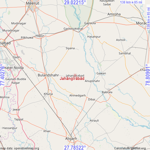
Jahāngīrābād GPS coordinates[2]
28° 24' 19.764" North, 78° 6' 21.168" East
| Map corner | latitude | longitude |
|---|---|---|
| Upper-left | 29.02215°, | 77.40276° |
| Center: | 28.40549°, | 78.10588° |
| Lower-right: | 27.78522°, | 78.80901° |
| Map W x H: | 137.5×137.5 km | = 85.4×85.4mi |
| max Lat: | 34.9274° ⇑13.6% North |
| Jahāngīrābād: | 28.40549° |
| min Lat: | ⇓86.4% South 8.09008° |
| min Long | Jahāngīrābā | max Long |
| 68.82655° | 78.10588° | 96.81° |
| W 49.9%⇐ | ⇒50.1% E |
Elevation
Elevation of Jahāngīrābād is 206 m = 676 ft, and this is 89.6 m = 294 ft below average elevation for this country.
| Max E: |
3681 m = 12077 ft | 49.3% |
| Avg. | 295.6 m = 970 ft | |
| Jahāngīrābād | 206 m = 676 ft | |
Min E: |
1 m = 3 ft | 50.7% |
See also: Jahāngīrābād elevation on elevation.city.
Geographical zone
Jahāngīrābād is located in North temperate zone (between Tropic of Cancer and the Arctic Circle). Distance of this Northern Tropic circle is 552.5 km =343.3 mi to South.| Distance of | km | miles | from Jahāngīrābād |
|---|---|---|---|
| North Pole | 6848.7 | 4255.6 | to North |
| Arctic Circle | 4242.8 | 2636.4 | to North |
| Tropic Cancer | 552.5 | 343.3 | to South |
| Equator | 3158.4 | 1962.5 | to South |


Nearby cities:
15 places around Jahāngīrābād: (largest is in red/bold)
• Anūpshahr
16.8 km =10.4 mi,  108°
108°
• Babrāla
33.3 km =20.7 mi,  118°
118°
• Bulandshahr
24.3 km =15.1 mi,  269°
269°
• Dibai
26.7 km =16.6 mi,  145°
145°
• Gawān
24.1 km =15 mi,  86°
86°
• Gulāothi
36.8 km =22.9 mi,  303°
303°
• Gunnaur
37.5 km =23.3 mi, 119°
• Hasanpur
39.3 km =24.4 mi,  26°
26°
• Khurja
29.8 km =18.5 mi,  235°
235°
• Khānpur
14.9 km =9.3 mi,  344°
344°
• Naraura
35.7 km =22.2 mi,  129°
129°
• Pahāsu
26.3 km =16.3 mi,  189°
189°
• Saidpur
29.9 km =18.6 mi,  319°
319°
• Shikārpūr
16.5 km =10.3 mi,  212°
212°
• Sikandarābād
40 km =24.9 mi,  277°
277°
Sources, notices
• [Note1] Compared only with cities in India existing in our database
• [Src1] Map data: © OpenStreetMap contributors (CC-BY-SA)
• [Src2] Other city data from geonames.org with taken over terms of usage.
• [Src3] Geographical zone / Annual Mean Temperature by Robert A. Rohde @ Wikipedia
