Kāpren geodata
Kāpren (Rajasthan) is a populated place; located in India in Asia/Kolkata (GMT+5.5) time zone. With population of 19,671 people, there are 2067 cities with bigger population in this country. Compared to other cities in India, 66.1% of cities are located further ↓South; 72.8% of cities are located further →East and 58.1% of cities have lower elevation than Kāpren. Note1


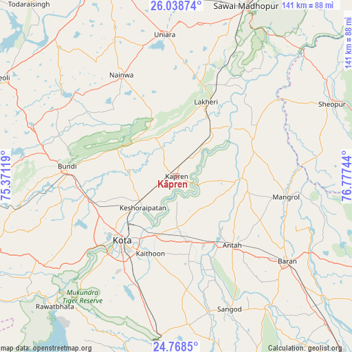
Kāpren GPS coordinates[2]
25° 24' 19.044" North, 76° 4' 27.516" East
| Map corner | latitude | longitude |
|---|---|---|
| Upper-left | 26.03874°, | 75.37119° |
| Center: | 25.40529°, | 76.07431° |
| Lower-right: | 24.7685°, | 76.77744° |
| Map W x H: | 141.2×141.2 km | = 87.7×87.7mi |
| max Lat: | 34.9274° ⇑33.9% North |
| Kāpren: | 25.40529° |
| min Lat: | ⇓66.1% South 8.09008° |
| min Long | Kāpren | max Long |
| 68.82655° | 76.07431° | 96.81° |
| W 27.2%⇐ | ⇒72.8% E |
Elevation
Elevation of Kāpren is 240 m = 787 ft, and this is 55.6 m = 182 ft below average elevation for this country.
| Max E: |
3681 m = 12077 ft | 41.9% |
| Avg. | 295.6 m = 970 ft | |
| Kāpren | 240 m = 787 ft | |
Min E: |
1 m = 3 ft | 58.1% |
See also: India elevation on elevation.city.
Geographical zone
Kāpren is located in North temperate zone (between Tropic of Cancer and the Arctic Circle). Distance of this Northern Tropic circle is 218.9 km =136 mi to South.| Distance of | km | miles | from Kāpren |
|---|---|---|---|
| North Pole | 7182.3 | 4462.9 | to North |
| Arctic Circle | 4576.4 | 2843.6 | to North |
| Tropic Cancer | 218.9 | 136 | to South |
| Equator | 2824.8 | 1755.2 | to South |


Nearby cities:
15 places around Kāpren: (largest is in red/bold)
• Anta
36.3 km =22.6 mi,  141°
141°
• Borkhera
45.4 km =28.2 mi,  286°
286°
• Bārān
56 km =34.8 mi,  127°
127°
• Būndi
44 km =27.3 mi,  274°
274°
• Chechat
73.6 km =45.7 mi,  195°
195°
• Keshorai Pātan
18.4 km =11.4 mi,  227°
227°
• Kota
34.2 km =21.3 mi,  223°
223°
• Lākheri
31.4 km =19.5 mi,  19°
19°
• Māngrol
44.5 km =27.7 mi,  100°
100°
• Nainwa
46.5 km =28.9 mi,  331°
331°
• Rāwatbhāta
71.8 km =44.6 mi, 222°
• Sangod
57.3 km =35.6 mi,  158°
158°
• Sawāi Mādhopur
73.8 km =45.9 mi, 21°
• Sheopur
68.7 km =42.7 mi,  65°
65°
• Udpura
75.4 km =46.9 mi,  187°
187°
Sources, notices
• [Note1] Compared only with cities in India existing in our database
• [Src1] Map data: © OpenStreetMap contributors (CC-BY-SA)
• [Src2] Other city data from geonames.org with taken over terms of usage.
• [Src3] Geographical zone / Annual Mean Temperature by Robert A. Rohde @ Wikipedia
