Kota geodata
Kota (Rajasthan) is a populated place; located in India in Asia/Kolkata (GMT+5.5) time zone. With population of 763,088 people, there are 60 cities with bigger population in this country. Compared to other cities in India, 64.3% of cities are located further ↓South; 75.3% of cities are located further →East and 62.4% of cities have lower elevation than Kota. Note1


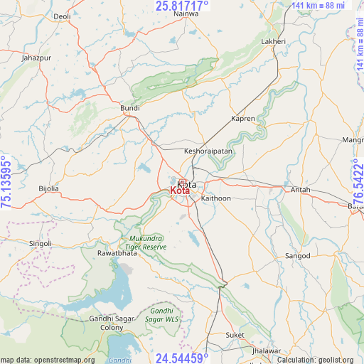
Kota GPS coordinates[2]
25° 10' 57.144" North, 75° 50' 20.652" East
| Map corner | latitude | longitude |
|---|---|---|
| Upper-left | 25.81717°, | 75.13595° |
| Center: | 25.18254°, | 75.83907° |
| Lower-right: | 24.54459°, | 76.5422° |
| Map W x H: | 141.5×141.5 km | = 87.9×87.9mi |
| max Lat: | 34.9274° ⇑35.7% North |
| Kota: | 25.18254° |
| min Lat: | ⇓64.3% South 8.09008° |
| min Long | Kota | max Long |
| 68.82655° | 75.83907° | 96.81° |
| W 24.7%⇐ | ⇒75.3% E |
Elevation
Elevation of Kota is 267 m = 876 ft, and this is 28.6 m = 94 ft below average elevation for this country.
| Max E: |
3681 m = 12077 ft | 37.6% |
| Avg. | 295.6 m = 970 ft | |
| Kota | 267 m = 876 ft | |
Min E: |
1 m = 3 ft | 62.4% |
See also: Kota elevation on elevation.city.
Geographical zone
Kota is located in North temperate zone (between Tropic of Cancer and the Arctic Circle). Distance of this Northern Tropic circle is 194.1 km =120.6 mi to South.| Distance of | km | miles | from Kota |
|---|---|---|---|
| North Pole | 7207 | 4478.2 | to North |
| Arctic Circle | 4601.1 | 2859 | to North |
| Tropic Cancer | 194.1 | 120.6 | to South |
| Equator | 2800 | 1739.8 | to South |


Nearby cities:
15 places around Kota: (largest is in red/bold)
• Anta
46.5 km =28.9 mi,  94°
94°
• Borkhera
42.6 km =26.5 mi,  332°
332°
• Bārān
68.8 km =42.8 mi,  97°
97°
• Būndi
34.9 km =21.7 mi,  324°
324°
• Chechat
46.5 km =28.9 mi,  174°
174°
• Keshorai Pātan
15.9 km =9.9 mi,  39°
39°
• Kāpren
34.2 km =21.3 mi, 43°
• Lākheri
64.2 km =39.9 mi,  31°
31°
• Nainwa
65.5 km =40.7 mi,  0°
0°
• Rāmganj Mandi
60.5 km =37.6 mi, 170°
• Rāwatbhāta
37.5 km =23.3 mi,  221°
221°
• Sangod
53.3 km =33.1 mi,  122°
122°
• Singoli
59.4 km =36.9 mi,  246°
246°
• Suket
63.1 km =39.2 mi,  161°
161°
• Udpura
51.8 km =32.2 mi, 164°
Sources, notices
• [Note1] Compared only with cities in India existing in our database
• [Src1] Map data: © OpenStreetMap contributors (CC-BY-SA)
• [Src2] Other city data from geonames.org with taken over terms of usage.
• [Src3] Geographical zone / Annual Mean Temperature by Robert A. Rohde @ Wikipedia
