Muzaffarpur geodata
Muzaffarpur (Bihar) is a populated place; located in India in Asia/Kolkata (GMT+5.5) time zone. With population of 333,200 people, there are 127 cities with bigger population in this country. Compared to other cities in India, 71.3% of cities are located further ↓South; 85.3% of cities are located further ←West and 76.7% of cities have higher elevation than Muzaffarpur. Note1


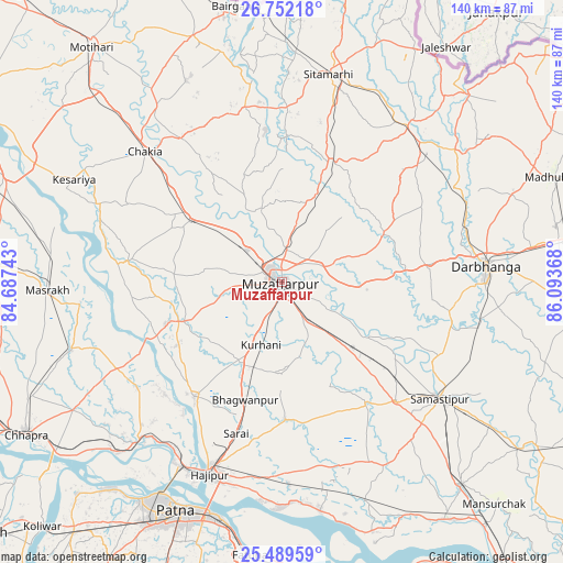
Muzaffarpur GPS coordinates[2]
26° 7' 21.324" North, 85° 23' 25.98" East
| Map corner | latitude | longitude |
|---|---|---|
| Upper-left | 26.75218°, | 84.68743° |
| Center: | 26.12259°, | 85.39055° |
| Lower-right: | 25.48959°, | 86.09368° |
| Map W x H: | 140.4×140.4 km | = 87.2×87.2mi |
| max Lat: | 34.9274° ⇑28.7% North |
| Muzaffarpur: | 26.12259° |
| min Lat: | ⇓71.3% South 8.09008° |
| min Long | Muzaffarpur | max Long |
| 68.82655° | 85.39055° | 96.81° |
| W 85.3%⇐ | ⇒14.7% E |
Elevation
Elevation of Muzaffarpur is 60 m = 197 ft, and this is 235.6 m = 773 ft below average elevation for this country.
| Max E: |
3681 m = 12077 ft | 76.7% |
| Avg. | 295.6 m = 970 ft | |
| Muzaffarpur | 60 m = 197 ft | |
Min E: |
1 m = 3 ft | 23.3% |
See also: Muzaffarpur elevation on elevation.city.
Geographical zone
Muzaffarpur is located in North temperate zone (between Tropic of Cancer and the Arctic Circle). Distance of this Northern Tropic circle is 298.6 km =185.5 mi to South.| Distance of | km | miles | from Muzaffarpur |
|---|---|---|---|
| North Pole | 7102.5 | 4413.3 | to North |
| Arctic Circle | 4496.6 | 2794.1 | to North |
| Tropic Cancer | 298.6 | 185.5 | to South |
| Equator | 2904.6 | 1804.8 | to South |


Nearby cities:
15 places around Muzaffarpur: (largest is in red/bold)
• Belsand
35.7 km =22.2 mi,  1°
1°
• Chākia
47.3 km =29.4 mi,  313°
313°
• Darbhanga
50.7 km =31.5 mi,  86°
86°
• Dhāka
65.3 km =40.6 mi,  340°
340°
• Dighwāra
56.7 km =35.2 mi,  222°
222°
• Dinapore
63.9 km =39.7 mi,  212°
212°
• Dumra
51.1 km =31.8 mi,  14°
14°
• Hājīpur
51.9 km =32.2 mi,  200°
200°
• Lālganj
35.6 km =22.1 mi, 217°
• Marhaura
54.8 km =34.1 mi,  252°
252°
• Patna
64.1 km =39.8 mi, 203°
• Pupri
49.7 km =30.9 mi,  38°
38°
• Samāstipur
48.5 km =30.1 mi,  126°
126°
• Sheohar
44.6 km =27.7 mi,  347°
347°
• Sītāmarhi
53.3 km =33.1 mi, 10°
Sources, notices
• [Note1] Compared only with cities in India existing in our database
• [Src1] Map data: © OpenStreetMap contributors (CC-BY-SA)
• [Src2] Other city data from geonames.org with taken over terms of usage.
• [Src3] Geographical zone / Annual Mean Temperature by Robert A. Rohde @ Wikipedia
