Marhaura geodata
Marhaura (Bihar) is a populated place; located in India in Asia/Kolkata (GMT+5.5) time zone. With population of 26,138 people, there are 1633 cities with bigger population in this country. Compared to other cities in India, 70.1% of cities are located further ↓South; 84% of cities are located further ←West and 77% of cities have higher elevation than Marhaura. Note1


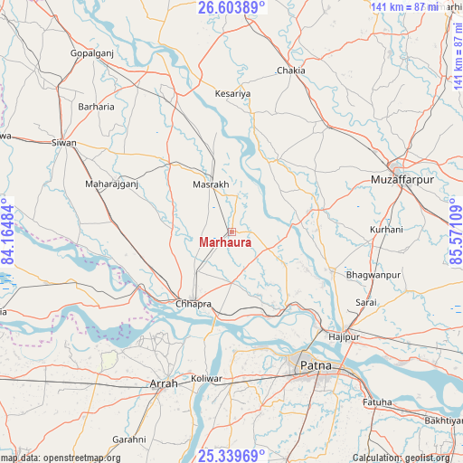
Marhaura GPS coordinates[2]
25° 58' 24.564" North, 84° 52' 4.656" East
| Map corner | latitude | longitude |
|---|---|---|
| Upper-left | 26.60389°, | 84.16484° |
| Center: | 25.97349°, | 84.86796° |
| Lower-right: | 25.33969°, | 85.57109° |
| Map W x H: | 140.6×140.6 km | = 87.4×87.4mi |
| max Lat: | 34.9274° ⇑29.9% North |
| Marhaura: | 25.97349° |
| min Lat: | ⇓70.1% South 8.09008° |
| min Long | Marhaura | max Long |
| 68.82655° | 84.86796° | 96.81° |
| W 84%⇐ | ⇒16% E |
Elevation
Elevation of Marhaura is 59 m = 194 ft, and this is 236.6 m = 776 ft below average elevation for this country.
| Max E: |
3681 m = 12077 ft | 77% |
| Avg. | 295.6 m = 970 ft | |
| Marhaura | 59 m = 194 ft | |
Min E: |
1 m = 3 ft | 23% |
See also: India elevation on elevation.city.
Geographical zone
Marhaura is located in North temperate zone (between Tropic of Cancer and the Arctic Circle). Distance of this Northern Tropic circle is 282.1 km =175.3 mi to South.| Distance of | km | miles | from Marhaura |
|---|---|---|---|
| North Pole | 7119.1 | 4423.6 | to North |
| Arctic Circle | 4513.2 | 2804.4 | to North |
| Tropic Cancer | 282.1 | 175.3 | to South |
| Equator | 2888 | 1794.5 | to South |


Nearby cities:
15 places around Marhaura: (largest is in red/bold)
• Arrah
50.7 km =31.5 mi,  203°
203°
• Barauli
53.3 km =33.1 mi,  328°
328°
• Chākia
52.3 km =32.5 mi,  19°
19°
• Chāpra
24.6 km =15.3 mi,  209°
209°
• Dighwāra
29.2 km =18.1 mi,  150°
150°
• Dinapore
41.5 km =25.8 mi, 154°
• Hājīpur
46.9 km =29.1 mi,  133°
133°
• Khagaul
47.3 km =29.4 mi,  157°
157°
• Koelwār
44.3 km =27.5 mi,  189°
189°
• Lālganj
32.7 km =20.3 mi,  110°
110°
• Mahārājgani
39.4 km =24.5 mi,  292°
292°
• Maner
36.4 km =22.6 mi,  179°
179°
• Patna
50 km =31.1 mi, 147°
• Reoti
50.9 km =31.6 mi,  254°
254°
• Revelganj
30.9 km =19.2 mi,  228°
228°
Sources, notices
• [Note1] Compared only with cities in India existing in our database
• [Src1] Map data: © OpenStreetMap contributors (CC-BY-SA)
• [Src2] Other city data from geonames.org with taken over terms of usage.
• [Src3] Geographical zone / Annual Mean Temperature by Robert A. Rohde @ Wikipedia
