Dhāka geodata
Dhāka (Bihar) is a populated place; located in India in Asia/Kolkata (GMT+5.5) time zone. With population of 36,111 people, there are 1206 cities with bigger population in this country. Compared to other cities in India, 75.9% of cities are located further ↓South; 84.7% of cities are located further ←West and 74.2% of cities have higher elevation than Dhāka. Note1


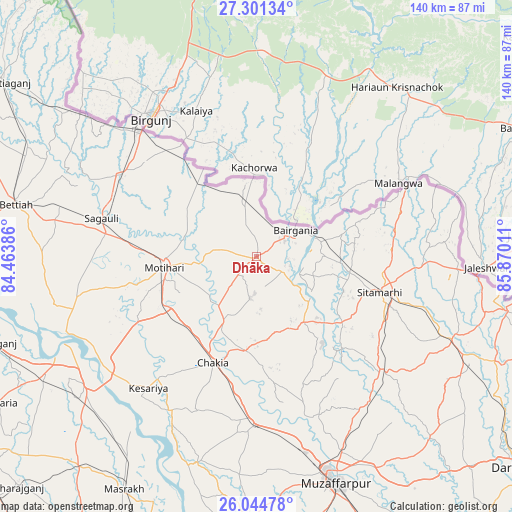
Dhāka GPS coordinates[2]
26° 40' 29.244" North, 85° 10' 1.128" East
| Map corner | latitude | longitude |
|---|---|---|
| Upper-left | 27.30134°, | 84.46386° |
| Center: | 26.67479°, | 85.16698° |
| Lower-right: | 26.04478°, | 85.87011° |
| Map W x H: | 139.7×139.7 km | = 86.8×86.8mi |
| max Lat: | 34.9274° ⇑24.1% North |
| Dhāka: | 26.67479° |
| min Lat: | ⇓75.9% South 8.09008° |
| min Long | Dhāka | max Long |
| 68.82655° | 85.16698° | 96.81° |
| W 84.7%⇐ | ⇒15.3% E |
Elevation
Elevation of Dhāka is 72 m = 236 ft, and this is 223.6 m = 734 ft below average elevation for this country.
| Max E: |
3681 m = 12077 ft | 74.2% |
| Avg. | 295.6 m = 970 ft | |
| Dhāka | 72 m = 236 ft | |
Min E: |
1 m = 3 ft | 25.8% |
See also: India elevation on elevation.city.
Geographical zone
Dhāka is located in North temperate zone (between Tropic of Cancer and the Arctic Circle). Distance of this Northern Tropic circle is 360 km =223.7 mi to South.| Distance of | km | miles | from Dhāka |
|---|---|---|---|
| North Pole | 7041.1 | 4375.1 | to North |
| Arctic Circle | 4435.2 | 2755.9 | to North |
| Tropic Cancer | 360 | 223.7 | to South |
| Equator | 2966 | 1843 | to South |


Nearby cities:
15 places around Dhāka: (largest is in red/bold)
• Bairāgnia
12.8 km =8 mi,  55°
55°
• Barauli
66.3 km =41.2 mi,  240°
240°
• Belsand
34.7 km =21.6 mi,  137°
137°
• Bettiah
67.4 km =41.9 mi,  282°
282°
• Chākia
31.2 km =19.4 mi,  202°
202°
• Dumra
37.1 km =23.1 mi,  108°
108°
• Gopālganj
75.8 km =47.1 mi,  252°
252°
• Marhaura
83.5 km =51.9 mi, 200°
• Mothīhāri
25.1 km =15.6 mi,  263°
263°
• Muzaffarpur
65.3 km =40.6 mi,  160°
160°
• Pupri
57.9 km =36 mi, 113°
• Raxaul
46.2 km =28.7 mi,  317°
317°
• Sagauli
43.2 km =26.8 mi, 283°
• Sheohar
21.9 km =13.6 mi, 144°
• Sītāmarhi
33.4 km =20.8 mi, 105°
Sources, notices
• [Note1] Compared only with cities in India existing in our database
• [Src1] Map data: © OpenStreetMap contributors (CC-BY-SA)
• [Src2] Other city data from geonames.org with taken over terms of usage.
• [Src3] Geographical zone / Annual Mean Temperature by Robert A. Rohde @ Wikipedia
