Dumra geodata
Dumra (Bihar) is a populated place; located in India in Asia/Kolkata (GMT+5.5) time zone. With population of 15,778 people, there are 2393 cities with bigger population in this country. Compared to other cities in India, 75.2% of cities are located further ↓South; 85.6% of cities are located further ←West and 74.6% of cities have higher elevation than Dumra. Note1


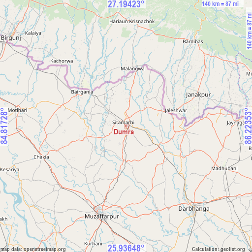
Dumra GPS coordinates[2]
26° 34' 1.488" North, 85° 31' 13.44" East
| Map corner | latitude | longitude |
|---|---|---|
| Upper-left | 27.19423°, | 84.81728° |
| Center: | 26.56708°, | 85.5204° |
| Lower-right: | 25.93648°, | 86.22353° |
| Map W x H: | 139.8×139.8 km | = 86.9×86.9mi |
| max Lat: | 34.9274° ⇑24.8% North |
| Dumra: | 26.56708° |
| min Lat: | ⇓75.2% South 8.09008° |
| min Long | Dumra | max Long |
| 68.82655° | 85.5204° | 96.81° |
| W 85.6%⇐ | ⇒14.4% E |
Elevation
Elevation of Dumra is 70 m = 230 ft, and this is 225.6 m = 740 ft below average elevation for this country.
| Max E: |
3681 m = 12077 ft | 74.6% |
| Avg. | 295.6 m = 970 ft | |
| Dumra | 70 m = 230 ft | |
Min E: |
1 m = 3 ft | 25.4% |
See also: India elevation on elevation.city.
Geographical zone
Dumra is located in North temperate zone (between Tropic of Cancer and the Arctic Circle). Distance of this Northern Tropic circle is 348.1 km =216.3 mi to South.| Distance of | km | miles | from Dumra |
|---|---|---|---|
| North Pole | 7053.1 | 4382.6 | to North |
| Arctic Circle | 4447.2 | 2763.4 | to North |
| Tropic Cancer | 348.1 | 216.3 | to South |
| Equator | 2954 | 1835.5 | to South |


Nearby cities:
15 places around Dumra: (largest is in red/bold)
• Bairāgnia
31.2 km =19.4 mi,  308°
308°
• Belsand
18.2 km =11.3 mi,  220°
220°
• Bhagirathpur
63.4 km =39.4 mi,  121°
121°
• Chākia
50 km =31.1 mi,  250°
250°
• Darbhanga
59.5 km =37 mi,  140°
140°
• Dhāka
37.1 km =23.1 mi,  288°
288°
• Jaynagar
61.5 km =38.2 mi,  87°
87°
• Madhubani
59.8 km =37.2 mi,  113°
113°
• Mothīhāri
60.7 km =37.7 mi,  278°
278°
• Muzaffarpur
51.1 km =31.8 mi,  194°
194°
• Pupri
21.1 km =13.1 mi, 120°
• Raxaul
80.8 km =50.2 mi,  304°
304°
• Sagauli
80.2 km =49.8 mi, 285°
• Sheohar
23.3 km =14.5 mi,  255°
255°
• Sītāmarhi
4.2 km =2.6 mi, 314°
Sources, notices
• [Note1] Compared only with cities in India existing in our database
• [Src1] Map data: © OpenStreetMap contributors (CC-BY-SA)
• [Src2] Other city data from geonames.org with taken over terms of usage.
• [Src3] Geographical zone / Annual Mean Temperature by Robert A. Rohde @ Wikipedia
