Sheohar geodata
Sheohar (Bihar) is a populated place; located in India in Asia/Kolkata (GMT+5.5) time zone. With population of 24,979 people, there are 1706 cities with bigger population in this country. Compared to other cities in India, 74.9% of cities are located further ↓South; 85% of cities are located further ←West and 74.4% of cities have higher elevation than Sheohar. Note1


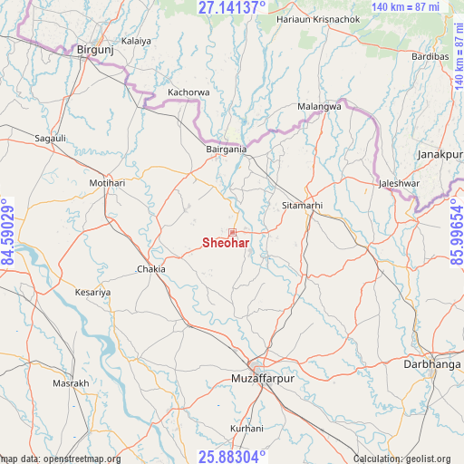
Sheohar GPS coordinates[2]
26° 30' 50.148" North, 85° 17' 36.276" East
| Map corner | latitude | longitude |
|---|---|---|
| Upper-left | 27.14137°, | 84.59029° |
| Center: | 26.51393°, | 85.29341° |
| Lower-right: | 25.88304°, | 85.99654° |
| Map W x H: | 139.9×139.9 km | = 86.9×86.9mi |
| max Lat: | 34.9274° ⇑25.1% North |
| Sheohar: | 26.51393° |
| min Lat: | ⇓74.9% South 8.09008° |
| min Long | Sheohar | max Long |
| 68.82655° | 85.29341° | 96.81° |
| W 85%⇐ | ⇒15% E |
Elevation
Elevation of Sheohar is 71 m = 233 ft, and this is 224.6 m = 737 ft below average elevation for this country.
| Max E: |
3681 m = 12077 ft | 74.4% |
| Avg. | 295.6 m = 970 ft | |
| Sheohar | 71 m = 233 ft | |
Min E: |
1 m = 3 ft | 25.6% |
See also: India elevation on elevation.city.
Geographical zone
Sheohar is located in North temperate zone (between Tropic of Cancer and the Arctic Circle). Distance of this Northern Tropic circle is 342.2 km =212.6 mi to South.| Distance of | km | miles | from Sheohar |
|---|---|---|---|
| North Pole | 7059 | 4386.3 | to North |
| Arctic Circle | 4453.1 | 2767 | to North |
| Tropic Cancer | 342.2 | 212.6 | to South |
| Equator | 2948.1 | 1831.9 | to South |


Nearby cities:
15 places around Sheohar: (largest is in red/bold)
• Bairāgnia
25.3 km =15.7 mi,  355°
355°
• Barauli
71.9 km =44.7 mi,  258°
258°
• Belsand
13.2 km =8.2 mi,  126°
126°
• Chākia
26.9 km =16.7 mi,  246°
246°
• Darbhanga
72.4 km =45 mi,  123°
123°
• Dhāka
21.9 km =13.6 mi,  324°
324°
• Dumra
23.3 km =14.5 mi,  75°
75°
• Lālganj
72.7 km =45.2 mi,  189°
189°
• Marhaura
73.6 km =45.7 mi,  215°
215°
• Mothīhāri
40.4 km =25.1 mi,  291°
291°
• Muzaffarpur
44.6 km =27.7 mi,  167°
167°
• Pupri
41.1 km =25.5 mi,  96°
96°
• Raxaul
67.9 km =42.2 mi, 319°
• Sagauli
61.3 km =38.1 mi,  296°
296°
• Sītāmarhi
21.5 km =13.4 mi,  65°
65°
Sources, notices
• [Note1] Compared only with cities in India existing in our database
• [Src1] Map data: © OpenStreetMap contributors (CC-BY-SA)
• [Src2] Other city data from geonames.org with taken over terms of usage.
• [Src3] Geographical zone / Annual Mean Temperature by Robert A. Rohde @ Wikipedia
