Chākia geodata
Chākia (Bihar) is a populated place; located in India in Asia/Kolkata (GMT+5.5) time zone. With population of 17,831 people, there are 2215 cities with bigger population in this country. Compared to other cities in India, 73.8% of cities are located further ↓South; 84.4% of cities are located further ←West and 75.2% of cities have higher elevation than Chākia. Note1


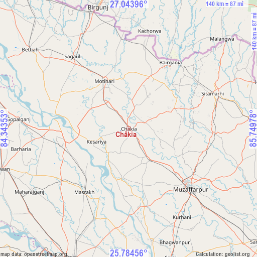
Chākia GPS coordinates[2]
26° 24' 57.528" North, 85° 2' 47.94" East
| Map corner | latitude | longitude |
|---|---|---|
| Upper-left | 27.04396°, | 84.34353° |
| Center: | 26.41598°, | 85.04665° |
| Lower-right: | 25.78456°, | 85.74978° |
| Map W x H: | 140×140 km | = 87×87mi |
| max Lat: | 34.9274° ⇑26.2% North |
| Chākia: | 26.41598° |
| min Lat: | ⇓73.8% South 8.09008° |
| min Long | Chākia | max Long |
| 68.82655° | 85.04665° | 96.81° |
| W 84.4%⇐ | ⇒15.6% E |
Elevation
Elevation of Chākia is 67 m = 220 ft, and this is 228.6 m = 750 ft below average elevation for this country.
| Max E: |
3681 m = 12077 ft | 75.2% |
| Avg. | 295.6 m = 970 ft | |
| Chākia | 67 m = 220 ft | |
Min E: |
1 m = 3 ft | 24.8% |
See also: India elevation on elevation.city.
Geographical zone
Chākia is located in North temperate zone (between Tropic of Cancer and the Arctic Circle). Distance of this Northern Tropic circle is 331.3 km =205.9 mi to South.| Distance of | km | miles | from Chākia |
|---|---|---|---|
| North Pole | 7069.9 | 4393 | to North |
| Arctic Circle | 4464 | 2773.8 | to North |
| Tropic Cancer | 331.3 | 205.9 | to South |
| Equator | 2937.2 | 1825.1 | to South |


Nearby cities:
15 places around Chākia: (largest is in red/bold)
• Bairāgnia
42.6 km =26.5 mi,  31°
31°
• Barauli
46 km =28.6 mi,  265°
265°
• Belsand
35.4 km =22 mi,  85°
85°
• Dhāka
31.2 km =19.4 mi,  22°
22°
• Dumra
50 km =31.1 mi,  70°
70°
• Gopālganj
60.6 km =37.7 mi,  275°
275°
• Lālganj
62.1 km =38.6 mi,  168°
168°
• Mahārājgani
63.9 km =39.7 mi,  237°
237°
• Marhaura
52.3 km =32.5 mi,  199°
199°
• Mothīhāri
28.9 km =18 mi,  333°
333°
• Muzaffarpur
47.3 km =29.4 mi,  133°
133°
• Pupri
65.6 km =40.8 mi,  84°
84°
• Sagauli
49 km =30.4 mi,  322°
322°
• Sheohar
26.9 km =16.7 mi, 66°
• Sītāmarhi
48.4 km =30.1 mi, 65°
Sources, notices
• [Note1] Compared only with cities in India existing in our database
• [Src1] Map data: © OpenStreetMap contributors (CC-BY-SA)
• [Src2] Other city data from geonames.org with taken over terms of usage.
• [Src3] Geographical zone / Annual Mean Temperature by Robert A. Rohde @ Wikipedia
