Belsand geodata
Belsand (Bihar) is a populated place; located in India in Asia/Kolkata (GMT+5.5) time zone. With population of 19,396 people, there are 2085 cities with bigger population in this country. Compared to other cities in India, 74% of cities are located further ↓South; 85.4% of cities are located further ←West and 75.2% of cities have higher elevation than Belsand. Note1


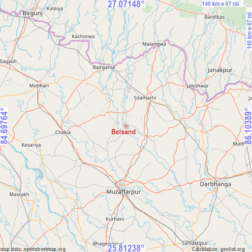
Belsand GPS coordinates[2]
26° 26' 37.14" North, 85° 24' 2.736" East
| Map corner | latitude | longitude |
|---|---|---|
| Upper-left | 27.07148°, | 84.69764° |
| Center: | 26.44365°, | 85.40076° |
| Lower-right: | 25.81238°, | 86.10389° |
| Map W x H: | 140×140 km | = 87×87mi |
| max Lat: | 34.9274° ⇑26% North |
| Belsand: | 26.44365° |
| min Lat: | ⇓74% South 8.09008° |
| min Long | Belsand | max Long |
| 68.82655° | 85.40076° | 96.81° |
| W 85.4%⇐ | ⇒14.6% E |
Elevation
Elevation of Belsand is 67 m = 220 ft, and this is 228.6 m = 750 ft below average elevation for this country.
| Max E: |
3681 m = 12077 ft | 75.2% |
| Avg. | 295.6 m = 970 ft | |
| Belsand | 67 m = 220 ft | |
Min E: |
1 m = 3 ft | 24.8% |
See also: India elevation on elevation.city.
Geographical zone
Belsand is located in North temperate zone (between Tropic of Cancer and the Arctic Circle). Distance of this Northern Tropic circle is 334.3 km =207.7 mi to South.| Distance of | km | miles | from Belsand |
|---|---|---|---|
| North Pole | 7066.8 | 4391.1 | to North |
| Arctic Circle | 4460.9 | 2771.9 | to North |
| Tropic Cancer | 334.3 | 207.7 | to South |
| Equator | 2940.3 | 1827 | to South |


Nearby cities:
15 places around Belsand: (largest is in red/bold)
• Bairāgnia
35.4 km =22 mi,  338°
338°
• Bhagirathpur
68.8 km =42.8 mi,  106°
106°
• Chākia
35.4 km =22 mi,  265°
265°
• Darbhanga
59.1 km =36.7 mi,  123°
123°
• Dhāka
34.7 km =21.6 mi,  317°
317°
• Dumra
18.2 km =11.3 mi,  40°
40°
• Lālganj
67.8 km =42.1 mi,  199°
199°
• Madhubani
67.6 km =42 mi,  98°
98°
• Marhaura
74.6 km =46.4 mi,  225°
225°
• Mothīhāri
53.3 km =33.1 mi,  295°
295°
• Muzaffarpur
35.7 km =22.2 mi,  181°
181°
• Pupri
30.2 km =18.8 mi,  84°
84°
• Sagauli
74.4 km =46.2 mi, 298°
• Sheohar
13.2 km =8.2 mi,  306°
306°
• Sītāmarhi
18.9 km =11.7 mi,  28°
28°
Sources, notices
• [Note1] Compared only with cities in India existing in our database
• [Src1] Map data: © OpenStreetMap contributors (CC-BY-SA)
• [Src2] Other city data from geonames.org with taken over terms of usage.
• [Src3] Geographical zone / Annual Mean Temperature by Robert A. Rohde @ Wikipedia
