Nanded geodata
Nanded (Maharashtra) is a populated place; located in India in Asia/Kolkata (GMT+5.5) time zone. With population of 550,564 people, there are 78 cities with bigger population in this country. Compared to other cities in India, 68% of cities are located further ↑North; 59.5% of cities are located further →East and 73.2% of cities have lower elevation than Nanded. Note1


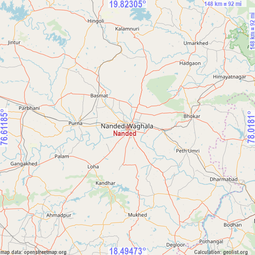
Nanded GPS coordinates[2]
19° 9' 36.828" North, 77° 18' 53.892" East
| Map corner | latitude | longitude |
|---|---|---|
| Upper-left | 19.82305°, | 76.61185° |
| Center: | 19.16023°, | 77.31497° |
| Lower-right: | 18.49473°, | 78.0181° |
| Map W x H: | 147.7×147.7 km | = 91.8×91.8mi |
| max Lat: | 34.9274° ⇑68% North |
| Nanded: | 19.16023° |
| min Lat: | ⇓32% South 8.09008° |
| min Long | Nanded | max Long |
| 68.82655° | 77.31497° | 96.81° |
| W 40.5%⇐ | ⇒59.5% E |
Elevation
Elevation of Nanded is 363 m = 1191 ft, and this is 67.4 m = 221 ft above average elevation for this country.
| Max E: |
3681 m = 12077 ft | 26.8% |
| Nanded | 363 m 1191 ft | |
| Avg. | 295.6 m = 970 ft | |
Min E: |
1 m = 3 ft | 73.2% |
See also: Nanded elevation on elevation.city.
Geographical zone
Nanded is located in North Torrid zone (between Equator and Tropic of Cancer). Distance of this Northern Tropic circle is 475.5 km =295.5 mi to North.| Distance of | km | miles | from Nanded |
|---|---|---|---|
| North Pole | 7876.6 | 4894.3 | to North |
| Arctic Circle | 5270.8 | 3275.1 | to North |
| Tropic Cancer | 475.5 | 295.5 | to North |
| Equator | 2130.4 | 1323.8 | to South |


Nearby cities:
15 places around Nanded: (largest is in red/bold)
• Ahmadpur
64.2 km =39.9 mi,  218°
218°
• Basmat
25 km =15.5 mi,  318°
318°
• Bhaisa
68.3 km =42.4 mi,  94°
94°
• Biloli
60.8 km =37.8 mi,  134°
134°
• Dharmābād
63.6 km =39.5 mi,  118°
118°
• Gangākher
63.1 km =39.2 mi,  250°
250°
• Hadgāon
51.9 km =32.2 mi,  44°
44°
• Hingoli
64.2 km =39.9 mi,  343°
343°
• Kalamnūri
57.1 km =35.5 mi,  359°
359°
• Kondalwādi
61.9 km =38.5 mi, 129°
• Mudkhed
19.8 km =12.3 mi, 91°
• Mukher
50.8 km =31.6 mi,  173°
173°
• Parbhani
58.4 km =36.3 mi,  281°
281°
• Pūrna
30.5 km =19 mi,  274°
274°
• Umarkhed
62.8 km =39 mi, 38°
Sources, notices
• [Note1] Compared only with cities in India existing in our database
• [Src1] Map data: © OpenStreetMap contributors (CC-BY-SA)
• [Src2] Other city data from geonames.org with taken over terms of usage.
• [Src3] Geographical zone / Annual Mean Temperature by Robert A. Rohde @ Wikipedia
