Partāpur geodata
Partāpur (Rajasthan) is a populated place; located in India in Asia/Kolkata (GMT+5.5) time zone. With population of 10,080 people, there are 2934 cities with bigger population in this country. Compared to other cities in India, 55.3% of cities are located further ↓South; 88.6% of cities are located further →East and 58.6% of cities have higher elevation than Partāpur. Note1


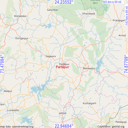
Partāpur GPS coordinates[2]
23° 35' 33.936" North, 74° 10' 26.256" East
| Map corner | latitude | longitude |
|---|---|---|
| Upper-left | 24.23552°, | 73.47084° |
| Center: | 23.59276°, | 74.17396° |
| Lower-right: | 22.94684°, | 74.87709° |
| Map W x H: | 143.3×143.3 km | = 89×89mi |
| max Lat: | 34.9274° ⇑44.7% North |
| Partāpur: | 23.59276° |
| min Lat: | ⇓55.3% South 8.09008° |
| min Long | Partāpur | max Long |
| 68.82655° | 74.17396° | 96.81° |
| W 11.4%⇐ | ⇒88.6% E |
Elevation
Elevation of Partāpur is 155 m = 509 ft, and this is 140.6 m = 461 ft below average elevation for this country.
| Max E: |
3681 m = 12077 ft | 58.6% |
| Avg. | 295.6 m = 970 ft | |
| Partāpur | 155 m = 509 ft | |
Min E: |
1 m = 3 ft | 41.4% |
See also: India elevation on elevation.city.
Geographical zone
Partāpur is located in North temperate zone (between Tropic of Cancer and the Arctic Circle). Distance of this Northern Tropic circle is 17.4 km =10.8 mi to South.| Distance of | km | miles | from Partāpur |
|---|---|---|---|
| North Pole | 7383.8 | 4588.1 | to North |
| Arctic Circle | 4777.9 | 2968.8 | to North |
| Tropic Cancer | 17.4 | 10.8 | to South |
| Equator | 2623.3 | 1630 | to South |


Nearby cities:
15 places around Partāpur: (largest is in red/bold)
• Bamna
81.7 km =50.8 mi,  132°
132°
• Bānswāra
28 km =17.4 mi,  101°
101°
• Dohad
85 km =52.8 mi,  174°
174°
• Dūngarpur
54.4 km =33.8 mi,  300°
300°
• Galiākot
17.6 km =10.9 mi,  242°
242°
• Kushālgarh
52.1 km =32.4 mi,  147°
147°
• Lūnāvāda
77.3 km =48 mi,  228°
228°
• Meghraj
68.1 km =42.3 mi,  261°
261°
• Morwa
83.8 km =52.1 mi,  204°
204°
• Mālpur
76.7 km =47.7 mi,  250°
250°
• Pratāpgarh
78.8 km =49 mi,  51°
51°
• Sailāna
77.7 km =48.3 mi, 100°
• Sālūmbar
61.7 km =38.3 mi,  347°
347°
• Thandla
76.8 km =47.7 mi, 147°
• Virpur
83.8 km =52.1 mi, 237°
Sources, notices
• [Note1] Compared only with cities in India existing in our database
• [Src1] Map data: © OpenStreetMap contributors (CC-BY-SA)
• [Src2] Other city data from geonames.org with taken over terms of usage.
• [Src3] Geographical zone / Annual Mean Temperature by Robert A. Rohde @ Wikipedia
