Limbdi geodata
Limbdi (Gujarat) is a populated place; located in India in Asia/Kolkata (GMT+5.5) time zone. With population of 41,740 people, there are 1058 cities with bigger population in this country. Compared to other cities in India, 52.6% of cities are located further ↑North; 97.6% of cities are located further →East and 79.2% of cities have higher elevation than Limbdi. Note1


Limbdi GPS coordinates[2]
22° 33' 54.252" North, 71° 48' 38.736" East
| Map corner | latitude | longitude |
|---|---|---|
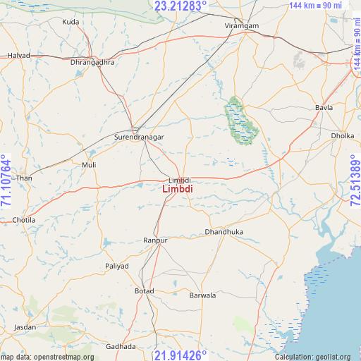
| Upper-left | 23.21283°, | 71.10764° |
| Center: | 22.56507°, | 71.81076° |
| Lower-right: | 21.91426°, | 72.51389° |
| Map W x H: | 144.4×144.4 km | = 89.7×89.7mi |
| max Lat: | 34.9274° ⇑52.6% North |
| Limbdi: | 22.56507° |
| min Lat: | ⇓47.4% South 8.09008° |
| min Long | Limbdi | max Long |
| 68.82655° | 71.81076° | 96.81° |
| W 2.4%⇐ | ⇒97.6% E |
Elevation
Elevation of Limbdi is 51 m = 167 ft, and this is 244.6 m = 802 ft below average elevation for this country.
| Max E: |
3681 m = 12077 ft | 79.2% |
| Avg. | 295.6 m = 970 ft | |
| Limbdi | 51 m = 167 ft | |
Min E: |
1 m = 3 ft | 20.8% |
See also: Limbdi elevation on elevation.city.
Geographical zone
Limbdi is located in North Torrid zone (between Equator and Tropic of Cancer). Distance of this Northern Tropic circle is 96.9 km =60.2 mi to North.| Distance of | km | miles | from Limbdi |
|---|---|---|---|
| North Pole | 7498.1 | 4659.1 | to North |
| Arctic Circle | 4892.2 | 3039.9 | to North |
| Tropic Cancer | 96.9 | 60.2 | to North |
| Equator | 2509 | 1559 | to South |


Nearby cities:
15 places around Limbdi: (largest is in red/bold)
• Botād
46.4 km =28.8 mi,  198°
198°
• Chotila
65 km =40.4 mi,  255°
255°
• Dhandhuka
27.2 km =16.9 mi,  138°
138°
• Dhola
76.1 km =47.3 mi,  182°
182°
• Dholka
67.2 km =41.8 mi,  74°
74°
• Dhrāngadhra
59 km =36.7 mi,  323°
323°
• Gadhada
70.4 km =43.7 mi, 199°
• Lakhtar
32.5 km =20.2 mi,  355°
355°
• Pāliyād
42.8 km =26.6 mi,  216°
216°
• Surendranagar
24.5 km =15.2 mi, 317°
• Sānand
75.4 km =46.9 mi,  50°
50°
• Sāyla
33.7 km =20.9 mi,  267°
267°
• Thān
62.8 km =39 mi, 270°
• Valabhīpur
75.5 km =46.9 mi,  174°
174°
• Vinchia
59.3 km =36.8 mi,  228°
228°
Sources, notices
• [Note1] Compared only with cities in India existing in our database
• [Src1] Map data: © OpenStreetMap contributors (CC-BY-SA)
• [Src2] Other city data from geonames.org with taken over terms of usage.
• [Src3] Geographical zone / Annual Mean Temperature by Robert A. Rohde @ Wikipedia
