Karārī geodata
Karārī (Uttar Pradesh) is a populated place; located in India in Asia/Kolkata (GMT+5.5) time zone. With population of 14,403 people, there are 2520 cities with bigger population in this country. Compared to other cities in India, 66.4% of cities are located further ↓South; 74.4% of cities are located further ←West and 66.6% of cities have higher elevation than Karārī. Note1


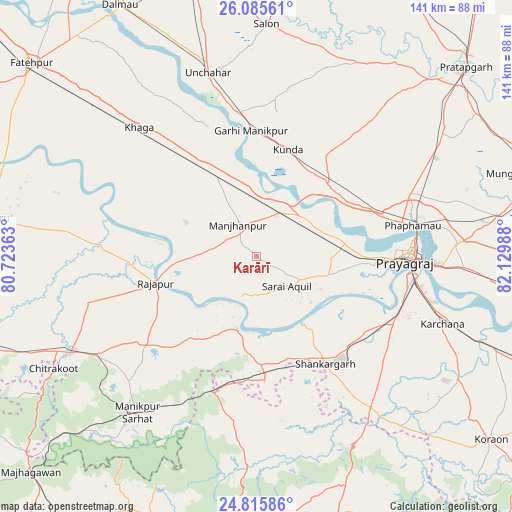
Karārī GPS coordinates[2]
25° 27' 8.676" North, 81° 25' 36.3" East
| Map corner | latitude | longitude |
|---|---|---|
| Upper-left | 26.08561°, | 80.72363° |
| Center: | 25.45241°, | 81.42675° |
| Lower-right: | 24.81586°, | 82.12988° |
| Map W x H: | 141.2×141.2 km | = 87.7×87.7mi |
| max Lat: | 34.9274° ⇑33.6% North |
| Karārī: | 25.45241° |
| min Lat: | ⇓66.4% South 8.09008° |
| min Long | Karārī | max Long |
| 68.82655° | 81.42675° | 96.81° |
| W 74.4%⇐ | ⇒25.6% E |
Elevation
Elevation of Karārī is 109 m = 358 ft, and this is 186.6 m = 612 ft below average elevation for this country.
| Max E: |
3681 m = 12077 ft | 66.6% |
| Avg. | 295.6 m = 970 ft | |
| Karārī | 109 m = 358 ft | |
Min E: |
1 m = 3 ft | 33.4% |
See also: India elevation on elevation.city.
Geographical zone
Karārī is located in North temperate zone (between Tropic of Cancer and the Arctic Circle). Distance of this Northern Tropic circle is 224.1 km =139.2 mi to South.| Distance of | km | miles | from Karārī |
|---|---|---|---|
| North Pole | 7177 | 4459.6 | to North |
| Arctic Circle | 4571.1 | 2840.3 | to North |
| Tropic Cancer | 224.1 | 139.2 | to South |
| Equator | 2830 | 1758.5 | to South |


Nearby cities:
15 places around Karārī: (largest is in red/bold)
• Allahābād
41.8 km =26 mi,  91°
91°
• Bharwāri
13.7 km =8.5 mi,  28°
28°
• Chail
20.8 km =12.9 mi,  97°
97°
• Jhūsi
48.1 km =29.9 mi, 91°
• Khāga
48.1 km =29.9 mi,  317°
317°
• Kishanpur
45.7 km =28.4 mi,  297°
297°
• Kotwa
48.1 km =29.9 mi,  193°
193°
• Kunda
30.7 km =19.1 mi,  16°
16°
• Manjhanpur
10.1 km =6.3 mi,  329°
329°
• Mānikpur
54.6 km =33.9 mi,  217°
217°
• Rājāpur
28.6 km =17.8 mi,  255°
255°
• Sarāi Ākil
11.7 km =7.3 mi,  134°
134°
• Shankargarh
35.7 km =22.2 mi,  147°
147°
• Sirāthu
23.8 km =14.8 mi, 332°
• Teonthar
56.6 km =35.2 mi,  157°
157°
Sources, notices
• [Note1] Compared only with cities in India existing in our database
• [Src1] Map data: © OpenStreetMap contributors (CC-BY-SA)
• [Src2] Other city data from geonames.org with taken over terms of usage.
• [Src3] Geographical zone / Annual Mean Temperature by Robert A. Rohde @ Wikipedia
