Manjhanpur geodata
Manjhanpur (Uttar Pradesh) is a populated place; located in India in Asia/Kolkata (GMT+5.5) time zone. With population of 16,939 people, there are 2291 cities with bigger population in this country. Compared to other cities in India, 67.1% of cities are located further ↓South; 74.2% of cities are located further ←West and 67.6% of cities have higher elevation than Manjhanpur. Note1


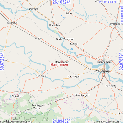
Manjhanpur GPS coordinates[2]
25° 31' 49.656" North, 81° 22' 32.376" East
| Map corner | latitude | longitude |
|---|---|---|
| Upper-left | 26.16324°, | 80.67254° |
| Center: | 25.53046°, | 81.37566° |
| Lower-right: | 24.89432°, | 82.07879° |
| Map W x H: | 141.1×141.1 km | = 87.7×87.7mi |
| max Lat: | 34.9274° ⇑32.9% North |
| Manjhanpur: | 25.53046° |
| min Lat: | ⇓67.1% South 8.09008° |
| min Long | Manjhanpur | max Long |
| 68.82655° | 81.37566° | 96.81° |
| W 74.2%⇐ | ⇒25.8% E |
Elevation
Elevation of Manjhanpur is 104 m = 341 ft, and this is 191.6 m = 629 ft below average elevation for this country.
| Max E: |
3681 m = 12077 ft | 67.6% |
| Avg. | 295.6 m = 970 ft | |
| Manjhanpur | 104 m = 341 ft | |
Min E: |
1 m = 3 ft | 32.4% |
See also: India elevation on elevation.city.
Geographical zone
Manjhanpur is located in North temperate zone (between Tropic of Cancer and the Arctic Circle). Distance of this Northern Tropic circle is 232.8 km =144.7 mi to South.| Distance of | km | miles | from Manjhanpur |
|---|---|---|---|
| North Pole | 7168.3 | 4454.2 | to North |
| Arctic Circle | 4562.5 | 2835 | to North |
| Tropic Cancer | 232.8 | 144.7 | to South |
| Equator | 2838.7 | 1763.9 | to South |


Nearby cities:
15 places around Manjhanpur: (largest is in red/bold)
• Allahābād
47.9 km =29.8 mi,  101°
101°
• Bharwāri
12.1 km =7.5 mi,  73°
73°
• Chail
28.2 km =17.5 mi,  114°
114°
• Jhūsi
54.2 km =33.7 mi, 101°
• Karārī
10.1 km =6.3 mi,  149°
149°
• Khāga
38.3 km =23.8 mi,  314°
314°
• Kishanpur
37.5 km =23.3 mi,  289°
289°
• Kotwa
55.8 km =34.7 mi,  185°
185°
• Kunda
25 km =15.5 mi,  33°
33°
• Lālganj
55.5 km =34.5 mi,  36°
36°
• Rājāpur
27.6 km =17.1 mi,  234°
234°
• Salon
55.9 km =34.7 mi,  8°
8°
• Sarāi Ākil
21.6 km =13.4 mi,  141°
141°
• Shankargarh
45.7 km =28.4 mi, 147°
• Sirāthu
13.8 km =8.6 mi,  335°
335°
Sources, notices
• [Note1] Compared only with cities in India existing in our database
• [Src1] Map data: © OpenStreetMap contributors (CC-BY-SA)
• [Src2] Other city data from geonames.org with taken over terms of usage.
• [Src3] Geographical zone / Annual Mean Temperature by Robert A. Rohde @ Wikipedia
