Bairāgnia geodata
Bairāgnia (Bihar) is a populated place; located in India in Asia/Kolkata (GMT+5.5) time zone. With population of 37,465 people, there are 1177 cities with bigger population in this country. Compared to other cities in India, 76.3% of cities are located further ↓South; 84.9% of cities are located further ←West and 72.7% of cities have higher elevation than Bairāgnia. Note1


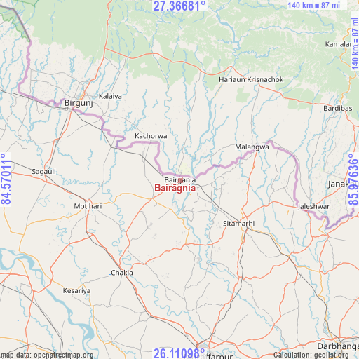
Bairāgnia GPS coordinates[2]
26° 44' 26.268" North, 85° 16' 23.628" East
| Map corner | latitude | longitude |
|---|---|---|
| Upper-left | 27.36681°, | 84.57011° |
| Center: | 26.74063°, | 85.27323° |
| Lower-right: | 26.11098°, | 85.97636° |
| Map W x H: | 139.6×139.6 km | = 86.7×86.7mi |
| max Lat: | 34.9274° ⇑23.7% North |
| Bairāgnia: | 26.74063° |
| min Lat: | ⇓76.3% South 8.09008° |
| min Long | Bairāgnia | max Long |
| 68.82655° | 85.27323° | 96.81° |
| W 84.9%⇐ | ⇒15.1% E |
Elevation
Elevation of Bairāgnia is 81 m = 266 ft, and this is 214.6 m = 704 ft below average elevation for this country.
| Max E: |
3681 m = 12077 ft | 72.7% |
| Avg. | 295.6 m = 970 ft | |
| Bairāgnia | 81 m = 266 ft | |
Min E: |
1 m = 3 ft | 27.3% |
See also: India elevation on elevation.city.
Geographical zone
Bairāgnia is located in North temperate zone (between Tropic of Cancer and the Arctic Circle). Distance of this Northern Tropic circle is 367.4 km =228.3 mi to South.| Distance of | km | miles | from Bairāgnia |
|---|---|---|---|
| North Pole | 7033.8 | 4370.6 | to North |
| Arctic Circle | 4427.9 | 2751.4 | to North |
| Tropic Cancer | 367.4 | 228.3 | to South |
| Equator | 2973.3 | 1847.5 | to South |


Nearby cities:
15 places around Bairāgnia: (largest is in red/bold)
• Barauli
79.1 km =49.2 mi,  239°
239°
• Belsand
35.4 km =22 mi,  158°
158°
• Bettiah
76.8 km =47.7 mi,  275°
275°
• Chākia
42.6 km =26.5 mi,  211°
211°
• Dhāka
12.8 km =8 mi, 235°
• Dumra
31.2 km =19.4 mi,  128°
128°
• Gopālganj
88.2 km =54.8 mi,  249°
249°
• Jaynagar
87.5 km =54.4 mi,  100°
100°
• Mothīhāri
36.9 km =22.9 mi, 253°
• Muzaffarpur
69.7 km =43.3 mi,  170°
170°
• Pupri
52.2 km =32.4 mi, 125°
• Raxaul
49.6 km =30.8 mi,  302°
302°
• Sagauli
52.7 km =32.7 mi,  272°
272°
• Sheohar
25.3 km =15.7 mi,  175°
175°
• Sītāmarhi
27.1 km =16.8 mi, 127°
Sources, notices
• [Note1] Compared only with cities in India existing in our database
• [Src1] Map data: © OpenStreetMap contributors (CC-BY-SA)
• [Src2] Other city data from geonames.org with taken over terms of usage.
• [Src3] Geographical zone / Annual Mean Temperature by Robert A. Rohde @ Wikipedia
