Saidpur geodata
Saidpur (Uttar Pradesh) is a populated place; located in India in Asia/Kolkata (GMT+5.5) time zone. With population of 14,496 people, there are 2511 cities with bigger population in this country. Compared to other cities in India, 87.3% of cities are located further ↓South; 52.2% of cities are located further →East and 52.5% of cities have lower elevation than Saidpur. Note1


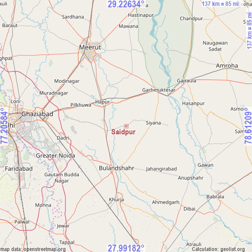
Saidpur GPS coordinates[2]
28° 36' 39.204" North, 77° 54' 32.256" East
| Map corner | latitude | longitude |
|---|---|---|
| Upper-left | 29.22634°, | 77.20584° |
| Center: | 28.61089°, | 77.90896° |
| Lower-right: | 27.99182°, | 78.61209° |
| Map W x H: | 137.3×137.3 km | = 85.3×85.3mi |
| max Lat: | 34.9274° ⇑12.7% North |
| Saidpur: | 28.61089° |
| min Lat: | ⇓87.3% South 8.09008° |
| min Long | Saidpur | max Long |
| 68.82655° | 77.90896° | 96.81° |
| W 47.8%⇐ | ⇒52.2% E |
Elevation
Elevation of Saidpur is 215 m = 705 ft, and this is 80.6 m = 264 ft below average elevation for this country.
| Max E: |
3681 m = 12077 ft | 47.5% |
| Avg. | 295.6 m = 970 ft | |
| Saidpur | 215 m = 705 ft | |
Min E: |
1 m = 3 ft | 52.5% |
See also: India elevation on elevation.city.
Geographical zone
Saidpur is located in North temperate zone (between Tropic of Cancer and the Arctic Circle). Distance of this Northern Tropic circle is 575.3 km =357.5 mi to South.| Distance of | km | miles | from Saidpur |
|---|---|---|---|
| North Pole | 6825.8 | 4241.4 | to North |
| Arctic Circle | 4219.9 | 2622.1 | to North |
| Tropic Cancer | 575.3 | 357.5 | to South |
| Equator | 3181.2 | 1976.7 | to South |


Nearby cities:
15 places around Saidpur: (largest is in red/bold)
• Babugarh
13.9 km =8.6 mi,  334°
334°
• Bulandshahr
23.6 km =14.7 mi,  192°
192°
• Bīlāspur
37 km =23 mi,  228°
228°
• Dādri
35.3 km =21.9 mi,  259°
259°
• Farīdnagar
32.5 km =20.2 mi,  302°
302°
• Garhmuktesar
27.2 km =16.9 mi,  43°
43°
• Gulāothi
11.6 km =7.2 mi, 258°
• Hāpur
18.2 km =11.3 mi,  316°
316°
• Jahāngīrābād
29.9 km =18.6 mi,  139°
139°
• Kharkhauda
29.9 km =18.6 mi, 326°
• Khānpur
17.5 km =10.9 mi,  119°
119°
• Kithor
28.6 km =17.8 mi,  5°
5°
• Pilkhua
27.2 km =16.9 mi,  294°
294°
• Shikārpūr
38.1 km =23.7 mi,  164°
164°
• Sikandarābād
27 km =16.8 mi, 229°
Sources, notices
• [Note1] Compared only with cities in India existing in our database
• [Src1] Map data: © OpenStreetMap contributors (CC-BY-SA)
• [Src2] Other city data from geonames.org with taken over terms of usage.
• [Src3] Geographical zone / Annual Mean Temperature by Robert A. Rohde @ Wikipedia
