Khānpur geodata
Khānpur (Uttar Pradesh) is a populated place; located in India in Asia/Kolkata (GMT+5.5) time zone. With population of 14,688 people, there are 2496 cities with bigger population in this country. Compared to other cities in India, 86.8% of cities are located further ↓South; 50.7% of cities are located further →East and 51.6% of cities have lower elevation than Khānpur. Note1


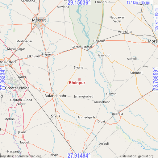
Khānpur GPS coordinates[2]
28° 32' 4.056" North, 78° 3' 55.656" East
| Map corner | latitude | longitude |
|---|---|---|
| Upper-left | 29.15036°, | 77.36234° |
| Center: | 28.53446°, | 78.06546° |
| Lower-right: | 27.91494°, | 78.76859° |
| Map W x H: | 137.4×137.4 km | = 85.4×85.4mi |
| max Lat: | 34.9274° ⇑13.2% North |
| Khānpur: | 28.53446° |
| min Lat: | ⇓86.8% South 8.09008° |
| min Long | Khānpur | max Long |
| 68.82655° | 78.06546° | 96.81° |
| W 49.3%⇐ | ⇒50.7% E |
Elevation
Elevation of Khānpur is 211 m = 692 ft, and this is 84.6 m = 278 ft below average elevation for this country.
| Max E: |
3681 m = 12077 ft | 48.4% |
| Avg. | 295.6 m = 970 ft | |
| Khānpur | 211 m = 692 ft | |
Min E: |
1 m = 3 ft | 51.6% |
See also: India elevation on elevation.city.
Geographical zone
Khānpur is located in North temperate zone (between Tropic of Cancer and the Arctic Circle). Distance of this Northern Tropic circle is 566.8 km =352.2 mi to South.| Distance of | km | miles | from Khānpur |
|---|---|---|---|
| North Pole | 6834.3 | 4246.6 | to North |
| Arctic Circle | 4228.4 | 2627.4 | to North |
| Tropic Cancer | 566.8 | 352.2 | to South |
| Equator | 3172.7 | 1971.4 | to South |


Nearby cities:
15 places around Khānpur: (largest is in red/bold)
• Anūpshahr
28 km =17.4 mi,  134°
134°
• Babugarh
30 km =18.6 mi,  314°
314°
• Bulandshahr
25 km =15.5 mi,  234°
234°
• Gajraula
38.6 km =24 mi,  26°
26°
• Garhmuktesar
28.3 km =17.6 mi,  7°
7°
• Gawān
30.8 km =19.1 mi,  114°
114°
• Gulāothi
27.3 km =17 mi,  282°
282°
• Hasanpur
29.9 km =18.6 mi,  45°
45°
• Hāpur
35.3 km =21.9 mi, 308°
• Jahāngīrābād
14.9 km =9.3 mi,  164°
164°
• Khurja
37.4 km =23.2 mi,  213°
213°
• Kithor
39 km =24.2 mi,  341°
341°
• Saidpur
17.5 km =10.9 mi,  299°
299°
• Shikārpūr
28.7 km =17.8 mi,  190°
190°
• Sikandarābād
36.9 km =22.9 mi,  255°
255°
Sources, notices
• [Note1] Compared only with cities in India existing in our database
• [Src1] Map data: © OpenStreetMap contributors (CC-BY-SA)
• [Src2] Other city data from geonames.org with taken over terms of usage.
• [Src3] Geographical zone / Annual Mean Temperature by Robert A. Rohde @ Wikipedia
