Gulāothi geodata
Gulāothi (Uttar Pradesh) is a populated place; located in India in Asia/Kolkata (GMT+5.5) time zone. With population of 46,647 people, there are 948 cities with bigger population in this country. Compared to other cities in India, 87.1% of cities are located further ↓South; 53.7% of cities are located further →East and 51.6% of cities have lower elevation than Gulāothi. Note1


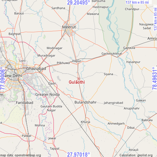
Gulāothi GPS coordinates[2]
28° 35' 21.768" North, 77° 47' 35.448" East
| Map corner | latitude | longitude |
|---|---|---|
| Upper-left | 29.20495°, | 77.09006° |
| Center: | 28.58938°, | 77.79318° |
| Lower-right: | 27.97018°, | 78.49631° |
| Map W x H: | 137.3×137.3 km | = 85.3×85.3mi |
| max Lat: | 34.9274° ⇑12.9% North |
| Gulāothi: | 28.58938° |
| min Lat: | ⇓87.1% South 8.09008° |
| min Long | Gulāothi | max Long |
| 68.82655° | 77.79318° | 96.81° |
| W 46.3%⇐ | ⇒53.7% E |
Elevation
Elevation of Gulāothi is 211 m = 692 ft, and this is 84.6 m = 278 ft below average elevation for this country.
| Max E: |
3681 m = 12077 ft | 48.4% |
| Avg. | 295.6 m = 970 ft | |
| Gulāothi | 211 m = 692 ft | |
Min E: |
1 m = 3 ft | 51.6% |
See also: Gulāothi elevation on elevation.city.
Geographical zone
Gulāothi is located in North temperate zone (between Tropic of Cancer and the Arctic Circle). Distance of this Northern Tropic circle is 572.9 km =356 mi to South.| Distance of | km | miles | from Gulāothi |
|---|---|---|---|
| North Pole | 6828.2 | 4242.8 | to North |
| Arctic Circle | 4222.3 | 2623.6 | to North |
| Tropic Cancer | 572.9 | 356 | to South |
| Equator | 3178.8 | 1975.2 | to South |


Nearby cities:
15 places around Gulāothi: (largest is in red/bold)
• Babugarh
15.8 km =9.8 mi,  19°
19°
• Bulandshahr
21.6 km =13.4 mi,  162°
162°
• Bīlāspur
27.5 km =17.1 mi,  216°
216°
• Dankaur
35.3 km =21.9 mi, 221°
• Dādri
23.7 km =14.7 mi,  260°
260°
• Dāsna
28.2 km =17.5 mi,  290°
290°
• Farīdnagar
25.6 km =15.9 mi,  321°
321°
• Greater Noida
27.2 km =16.9 mi,  247°
247°
• Hāpur
15.7 km =9.8 mi,  355°
355°
• Kharkhauda
27.9 km =17.3 mi,  349°
349°
• Khānpur
27.3 km =17 mi,  102°
102°
• Kithor
34 km =21.1 mi, 24°
• Pilkhua
19.2 km =11.9 mi, 315°
• Saidpur
11.6 km =7.2 mi,  78°
78°
• Sikandarābād
17.8 km =11.1 mi,  210°
210°
Sources, notices
• [Note1] Compared only with cities in India existing in our database
• [Src1] Map data: © OpenStreetMap contributors (CC-BY-SA)
• [Src2] Other city data from geonames.org with taken over terms of usage.
• [Src3] Geographical zone / Annual Mean Temperature by Robert A. Rohde @ Wikipedia
