Shāhpur geodata
Shāhpur (Bihar) is a populated place; located in India in Asia/Kolkata (GMT+5.5) time zone. With population of 15,850 people, there are 2382 cities with bigger population in this country. Compared to other cities in India, 67.7% of cities are located further ↓South; 82.8% of cities are located further ←West and 75.6% of cities have higher elevation than Shāhpur. Note1


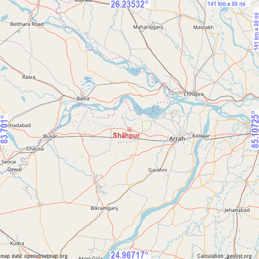
Shāhpur GPS coordinates[2]
25° 36' 10.548" North, 84° 24' 14.832" East
| Map corner | latitude | longitude |
|---|---|---|
| Upper-left | 26.23532°, | 83.701° |
| Center: | 25.60293°, | 84.40412° |
| Lower-right: | 24.96717°, | 85.10725° |
| Map W x H: | 141×141 km | = 87.6×87.6mi |
| max Lat: | 34.9274° ⇑32.3% North |
| Shāhpur: | 25.60293° |
| min Lat: | ⇓67.7% South 8.09008° |
| min Long | Shāhpur | max Long |
| 68.82655° | 84.40412° | 96.81° |
| W 82.8%⇐ | ⇒17.2% E |
Elevation
Elevation of Shāhpur is 66 m = 217 ft, and this is 229.6 m = 753 ft below average elevation for this country.
| Max E: |
3681 m = 12077 ft | 75.6% |
| Avg. | 295.6 m = 970 ft | |
| Shāhpur | 66 m = 217 ft | |
Min E: |
1 m = 3 ft | 24.4% |
See also: India elevation on elevation.city.
Geographical zone
Shāhpur is located in North temperate zone (between Tropic of Cancer and the Arctic Circle). Distance of this Northern Tropic circle is 240.9 km =149.7 mi to South.| Distance of | km | miles | from Shāhpur |
|---|---|---|---|
| North Pole | 7160.3 | 4449.2 | to North |
| Arctic Circle | 4554.4 | 2830 | to North |
| Tropic Cancer | 240.9 | 149.7 | to South |
| Equator | 2846.8 | 1768.9 | to South |


Nearby cities:
15 places around Shāhpur: (largest is in red/bold)
• Arrah
26.5 km =16.5 mi,  101°
101°
• Bikramganj
46.1 km =28.6 mi,  198°
198°
• Buxar
42.6 km =26.5 mi,  265°
265°
• Bānsdīh
36.4 km =22.6 mi,  329°
329°
• Chāpra
39.6 km =24.6 mi,  60°
60°
• Dumraon
25.9 km =16.1 mi,  257°
257°
• Jagdīspur
15.1 km =9.4 mi,  174°
174°
• Koelwār
39.5 km =24.5 mi,  93°
93°
• Koāth
34 km =21.1 mi,  205°
205°
• Mahārājgani
57.3 km =35.6 mi,  10°
10°
• Maner
47.2 km =29.3 mi,  84°
84°
• Maniar
48.5 km =30.1 mi, 331°
• Piro
30.1 km =18.7 mi,  179°
179°
• Reoti
27.7 km =17.2 mi,  354°
354°
• Revelganj
31.2 km =19.4 mi,  48°
48°
Sources, notices
• [Note1] Compared only with cities in India existing in our database
• [Src1] Map data: © OpenStreetMap contributors (CC-BY-SA)
• [Src2] Other city data from geonames.org with taken over terms of usage.
• [Src3] Geographical zone / Annual Mean Temperature by Robert A. Rohde @ Wikipedia
