Piro geodata
Piro (Bihar) is a populated place; located in India in Asia/Kolkata (GMT+5.5) time zone. With population of 28,967 people, there are 1498 cities with bigger population in this country. Compared to other cities in India, 65.5% of cities are located further ↓South; 82.9% of cities are located further ←West and 72.1% of cities have higher elevation than Piro. Note1


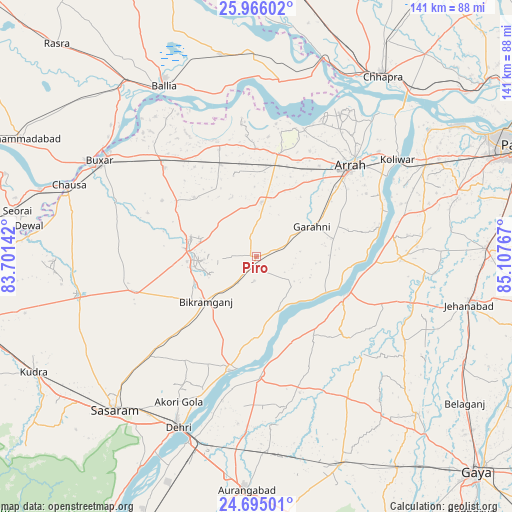
Piro GPS coordinates[2]
25° 19' 55.848" North, 84° 24' 16.344" East
| Map corner | latitude | longitude |
|---|---|---|
| Upper-left | 25.96602°, | 83.70142° |
| Center: | 25.33218°, | 84.40454° |
| Lower-right: | 24.69501°, | 85.10767° |
| Map W x H: | 141.3×141.3 km | = 87.8×87.8mi |
| max Lat: | 34.9274° ⇑34.5% North |
| Piro: | 25.33218° |
| min Lat: | ⇓65.5% South 8.09008° |
| min Long | Piro | max Long |
| 68.82655° | 84.40454° | 96.81° |
| W 82.9%⇐ | ⇒17.1% E |
Elevation
Elevation of Piro is 84 m = 276 ft, and this is 211.6 m = 694 ft below average elevation for this country.
| Max E: |
3681 m = 12077 ft | 72.1% |
| Avg. | 295.6 m = 970 ft | |
| Piro | 84 m = 276 ft | |
Min E: |
1 m = 3 ft | 27.9% |
See also: India elevation on elevation.city.
Geographical zone
Piro is located in North temperate zone (between Tropic of Cancer and the Arctic Circle). Distance of this Northern Tropic circle is 210.8 km =131 mi to South.| Distance of | km | miles | from Piro |
|---|---|---|---|
| North Pole | 7190.4 | 4467.9 | to North |
| Arctic Circle | 4584.5 | 2848.7 | to North |
| Tropic Cancer | 210.8 | 131 | to South |
| Equator | 2816.7 | 1750.2 | to South |


Nearby cities:
15 places around Piro: (largest is in red/bold)
• Arrah
36 km =22.4 mi,  46°
46°
• Bikramganj
20.2 km =12.6 mi,  228°
228°
• Buxar
50.4 km =31.3 mi,  302°
302°
• Daudnagar
33.1 km =20.6 mi,  180°
180°
• Dehri
52.8 km =32.8 mi,  205°
205°
• Dumraon
35.3 km =21.9 mi,  313°
313°
• Jagdīspur
15.2 km =9.4 mi,  5°
5°
• Jahānābād
60 km =37.3 mi,  102°
102°
• Koelwār
48.2 km =30 mi,  55°
55°
• Koāth
14.6 km =9.1 mi,  267°
267°
• Maner
58.5 km =36.4 mi, 53°
• Nāsriganj
32.1 km =19.9 mi,  193°
193°
• Reoti
57.7 km =35.9 mi,  357°
357°
• Revelganj
55.9 km =34.7 mi,  24°
24°
• Shāhpur
30.1 km =18.7 mi, 359°
Sources, notices
• [Note1] Compared only with cities in India existing in our database
• [Src1] Map data: © OpenStreetMap contributors (CC-BY-SA)
• [Src2] Other city data from geonames.org with taken over terms of usage.
• [Src3] Geographical zone / Annual Mean Temperature by Robert A. Rohde @ Wikipedia
