Koāth geodata
Koāth (Bihar) is a populated place; located in India in Asia/Kolkata (GMT+5.5) time zone. With population of 16,725 people, there are 2311 cities with bigger population in this country. Compared to other cities in India, 65.4% of cities are located further ↓South; 82.5% of cities are located further ←West and 71% of cities have higher elevation than Koāth. Note1


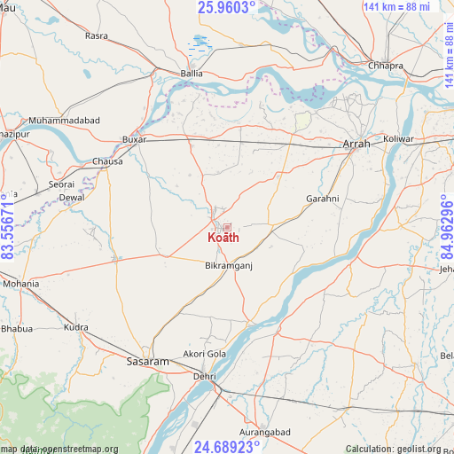
Koāth GPS coordinates[2]
25° 19' 35.148" North, 84° 15' 35.388" East
| Map corner | latitude | longitude |
|---|---|---|
| Upper-left | 25.9603°, | 83.55671° |
| Center: | 25.32643°, | 84.25983° |
| Lower-right: | 24.68923°, | 84.96296° |
| Map W x H: | 141.3×141.3 km | = 87.8×87.8mi |
| max Lat: | 34.9274° ⇑34.6% North |
| Koāth: | 25.32643° |
| min Lat: | ⇓65.4% South 8.09008° |
| min Long | Koāth | max Long |
| 68.82655° | 84.25983° | 96.81° |
| W 82.5%⇐ | ⇒17.5% E |
Elevation
Elevation of Koāth is 88 m = 289 ft, and this is 207.6 m = 681 ft below average elevation for this country.
| Max E: |
3681 m = 12077 ft | 71% |
| Avg. | 295.6 m = 970 ft | |
| Koāth | 88 m = 289 ft | |
Min E: |
1 m = 3 ft | 29% |
See also: India elevation on elevation.city.
Geographical zone
Koāth is located in North temperate zone (between Tropic of Cancer and the Arctic Circle). Distance of this Northern Tropic circle is 210.1 km =130.6 mi to South.| Distance of | km | miles | from Koāth |
|---|---|---|---|
| North Pole | 7191 | 4468.3 | to North |
| Arctic Circle | 4585.1 | 2849 | to North |
| Tropic Cancer | 210.1 | 130.6 | to South |
| Equator | 2816 | 1749.8 | to South |


Nearby cities:
15 places around Koāth: (largest is in red/bold)
• Arrah
47.9 km =29.8 mi,  57°
57°
• Bikramganj
12.9 km =8 mi,  182°
182°
• Buxar
39.4 km =24.5 mi,  314°
314°
• Bānsdīh
62.1 km =38.6 mi,  356°
356°
• Daudnagar
35.4 km =22 mi,  156°
156°
• Dehri
47.8 km =29.7 mi,  189°
189°
• Dumraon
27.4 km =17 mi,  336°
336°
• Jagdīspur
22.5 km =14 mi,  45°
45°
• Koelwār
60.9 km =37.8 mi, 62°
• Muhammadābād
60.2 km =37.4 mi,  302°
302°
• Nāsriganj
31.3 km =19.4 mi,  167°
167°
• Piro
14.6 km =9.1 mi,  87°
87°
• Reoti
59.5 km =37 mi,  11°
11°
• Revelganj
63.9 km =39.7 mi,  36°
36°
• Shāhpur
34 km =21.1 mi,  25°
25°
Sources, notices
• [Note1] Compared only with cities in India existing in our database
• [Src1] Map data: © OpenStreetMap contributors (CC-BY-SA)
• [Src2] Other city data from geonames.org with taken over terms of usage.
• [Src3] Geographical zone / Annual Mean Temperature by Robert A. Rohde @ Wikipedia
