Chāpra geodata
Chāpra (Bihar) is a populated place; located in India in Asia/Kolkata (GMT+5.5) time zone. With population of 201,597 people, there are 209 cities with bigger population in this country. Compared to other cities in India, 69% of cities are located further ↓South; 83.6% of cities are located further ←West and 76.5% of cities have higher elevation than Chāpra. Note1


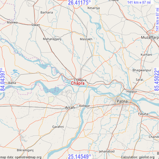
Chāpra GPS coordinates[2]
25° 46' 49.116" North, 84° 44' 49.524" East
| Map corner | latitude | longitude |
|---|---|---|
| Upper-left | 26.41175°, | 84.04397° |
| Center: | 25.78031°, | 84.74709° |
| Lower-right: | 25.14549°, | 85.45022° |
| Map W x H: | 140.8×140.8 km | = 87.5×87.5mi |
| max Lat: | 34.9274° ⇑31% North |
| Chāpra: | 25.78031° |
| min Lat: | ⇓69% South 8.09008° |
| min Long | Chāpra | max Long |
| 68.82655° | 84.74709° | 96.81° |
| W 83.6%⇐ | ⇒16.4% E |
Elevation
Elevation of Chāpra is 61 m = 200 ft, and this is 234.6 m = 770 ft below average elevation for this country.
| Max E: |
3681 m = 12077 ft | 76.5% |
| Avg. | 295.6 m = 970 ft | |
| Chāpra | 61 m = 200 ft | |
Min E: |
1 m = 3 ft | 23.5% |
See also: Chāpra elevation on elevation.city.
Geographical zone
Chāpra is located in North temperate zone (between Tropic of Cancer and the Arctic Circle). Distance of this Northern Tropic circle is 260.6 km =161.9 mi to South.| Distance of | km | miles | from Chāpra |
|---|---|---|---|
| North Pole | 7140.6 | 4437 | to North |
| Arctic Circle | 4534.7 | 2817.7 | to North |
| Tropic Cancer | 260.6 | 161.9 | to South |
| Equator | 2866.5 | 1781.2 | to South |


Nearby cities:
15 places around Chāpra: (largest is in red/bold)
• Arrah
26.3 km =16.3 mi,  198°
198°
• Dighwāra
26.6 km =16.5 mi,  98°
98°
• Dinapore
34.1 km =21.2 mi,  117°
117°
• Hājīpur
47.5 km =29.5 mi, 102°
• Jagdīspur
47.8 km =29.7 mi,  223°
223°
• Khagaul
37.4 km =23.2 mi,  126°
126°
• Koelwār
22.8 km =14.2 mi,  167°
167°
• Lālganj
43.8 km =27.2 mi,  77°
77°
• Mahārājgani
44 km =27.3 mi,  326°
326°
• Maner
19.5 km =12.1 mi,  139°
139°
• Marhaura
24.6 km =15.3 mi,  29°
29°
• Patna
44.1 km =27.4 mi, 118°
• Reoti
37.8 km =23.5 mi,  281°
281°
• Revelganj
11.2 km =7 mi, 275°
• Shāhpur
39.6 km =24.6 mi,  240°
240°
Sources, notices
• [Note1] Compared only with cities in India existing in our database
• [Src1] Map data: © OpenStreetMap contributors (CC-BY-SA)
• [Src2] Other city data from geonames.org with taken over terms of usage.
• [Src3] Geographical zone / Annual Mean Temperature by Robert A. Rohde @ Wikipedia
