Joshīmath geodata
Joshīmath (Uttarakhand) is a populated place; located in India in Asia/Kolkata (GMT+5.5) time zone. With population of 13,865 people, there are 2577 cities with bigger population in this country. Compared to other cities in India, 94.4% of cities are located further ↓South; 64.4% of cities are located further ←West and 99.1% of cities have lower elevation than Joshīmath. Note1


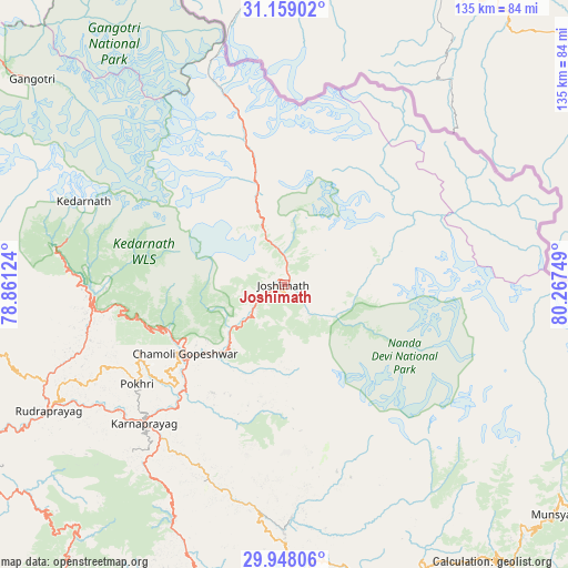
Joshīmath GPS coordinates[2]
30° 33' 19.548" North, 79° 33' 51.696" East
| Map corner | latitude | longitude |
|---|---|---|
| Upper-left | 31.15902°, | 78.86124° |
| Center: | 30.55543°, | 79.56436° |
| Lower-right: | 29.94806°, | 80.26749° |
| Map W x H: | 134.6×134.6 km | = 83.6×83.6mi |
| max Lat: | 34.9274° ⇑5.6% North |
| Joshīmath: | 30.55543° |
| min Lat: | ⇓94.4% South 8.09008° |
| min Long | Joshīmath | max Long |
| 68.82655° | 79.56436° | 96.81° |
| W 64.4%⇐ | ⇒35.6% E |
Elevation
Elevation of Joshīmath is 1821 m = 5974 ft, and this is 1525.4 m = 5005 ft above average elevation for this country.
| Max E: |
3681 m = 12077 ft | 0.90000000000001% |
| Joshīmath | 1821 m 5974 ft | |
| Avg. | 295.6 m = 970 ft | |
Min E: |
1 m = 3 ft | 99.1% |
See also: India elevation on elevation.city.
Geographical zone
Joshīmath is located in North temperate zone (between Tropic of Cancer and the Arctic Circle). Distance of this Northern Tropic circle is 791.5 km =491.8 mi to South.| Distance of | km | miles | from Joshīmath |
|---|---|---|---|
| North Pole | 6609.6 | 4107 | to North |
| Arctic Circle | 4003.7 | 2487.8 | to North |
| Tropic Cancer | 791.5 | 491.8 | to South |
| Equator | 3397.4 | 2111 | to South |


Nearby cities:
15 places around Joshīmath: (largest is in red/bold)
• Almora
106.9 km =66.4 mi,  175°
175°
• Bāgeshwar
82.3 km =51.1 mi,  165°
165°
• Devaprayāg
102.9 km =63.9 mi,  243°
243°
• Dhārchula
120.9 km =75.1 mi,  130°
130°
• Dwārāhāt
87.5 km =54.4 mi,  188°
188°
• Gangotri
76.9 km =47.8 mi,  309°
309°
• Kedārnāth
50.9 km =31.6 mi,  291°
291°
• Lansdowne
116.3 km =72.3 mi,  226°
226°
• Pauri
87.8 km =54.6 mi, 239°
• Pīpalkoti
19.3 km =12 mi,  221°
221°
• Rudraprayāg
63.3 km =39.3 mi, 241°
• Rānikhet
102.5 km =63.7 mi, 187°
• Srīnagar
83.6 km =51.9 mi, 243°
• Tehri
105.5 km =65.6 mi,  260°
260°
• Uttarkāshi
109 km =67.7 mi,  280°
280°
Sources, notices
• [Note1] Compared only with cities in India existing in our database
• [Src1] Map data: © OpenStreetMap contributors (CC-BY-SA)
• [Src2] Other city data from geonames.org with taken over terms of usage.
• [Src3] Geographical zone / Annual Mean Temperature by Robert A. Rohde @ Wikipedia
