Sangod geodata
Sangod (Rajasthan) is a populated place; located in India in Asia/Kolkata (GMT+5.5) time zone. With population of 19,842 people, there are 2054 cities with bigger population in this country. Compared to other cities in India, 63.1% of cities are located further ↓South; 70.7% of cities are located further →East and 62.3% of cities have lower elevation than Sangod. Note1


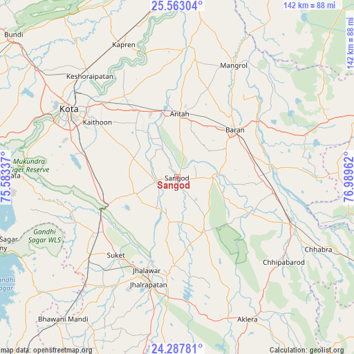
Sangod GPS coordinates[2]
24° 55' 37.452" North, 76° 17' 11.364" East
| Map corner | latitude | longitude |
|---|---|---|
| Upper-left | 25.56304°, | 75.58337° |
| Center: | 24.92707°, | 76.28649° |
| Lower-right: | 24.28781°, | 76.98962° |
| Map W x H: | 141.8×141.8 km | = 88.1×88.1mi |
| max Lat: | 34.9274° ⇑36.9% North |
| Sangod: | 24.92707° |
| min Lat: | ⇓63.1% South 8.09008° |
| min Long | Sangod | max Long |
| 68.82655° | 76.28649° | 96.81° |
| W 29.3%⇐ | ⇒70.7% E |
Elevation
Elevation of Sangod is 266 m = 873 ft, and this is 29.6 m = 97 ft below average elevation for this country.
| Max E: |
3681 m = 12077 ft | 37.7% |
| Avg. | 295.6 m = 970 ft | |
| Sangod | 266 m = 873 ft | |
Min E: |
1 m = 3 ft | 62.3% |
See also: India elevation on elevation.city.
Geographical zone
Sangod is located in North temperate zone (between Tropic of Cancer and the Arctic Circle). Distance of this Northern Tropic circle is 165.7 km =103 mi to South.| Distance of | km | miles | from Sangod |
|---|---|---|---|
| North Pole | 7235.4 | 4495.9 | to North |
| Arctic Circle | 4629.5 | 2876.6 | to North |
| Tropic Cancer | 165.7 | 103 | to South |
| Equator | 2771.6 | 1722.2 | to South |


Nearby cities:
15 places around Sangod: (largest is in red/bold)
• Aklera
63.8 km =39.6 mi,  153°
153°
• Anta
24.8 km =15.4 mi,  3°
3°
• Bārān
30.1 km =18.7 mi,  50°
50°
• Chechat
44.4 km =27.6 mi,  246°
246°
• Chhabra
63.4 km =39.4 mi,  117°
117°
• Jhālrapātan
44.3 km =27.5 mi,  195°
195°
• Jhālāwār
38.8 km =24.1 mi, 198°
• Keshorai Pātan
53.6 km =33.3 mi,  319°
319°
• Khānpur
24.3 km =15.1 mi, 152°
• Kota
53.3 km =33.1 mi,  302°
302°
• Kāpren
57.3 km =35.6 mi,  338°
338°
• Māngrol
50.2 km =31.2 mi,  26°
26°
• Rāmganj Mandi
46.6 km =29 mi,  227°
227°
• Suket
39.8 km =24.7 mi,  218°
218°
• Udpura
38.1 km =23.7 mi,  235°
235°
Sources, notices
• [Note1] Compared only with cities in India existing in our database
• [Src1] Map data: © OpenStreetMap contributors (CC-BY-SA)
• [Src2] Other city data from geonames.org with taken over terms of usage.
• [Src3] Geographical zone / Annual Mean Temperature by Robert A. Rohde @ Wikipedia
