Aklera geodata
Aklera (Rajasthan) is a populated place; located in India in Asia/Kolkata (GMT+5.5) time zone. With population of 19,683 people, there are 2065 cities with bigger population in this country. Compared to other cities in India, 60.1% of cities are located further ↓South; 67.7% of cities are located further →East and 69.4% of cities have lower elevation than Aklera. Note1


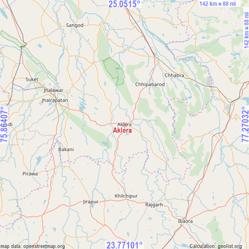
Aklera GPS coordinates[2]
24° 24' 46.368" North, 76° 34' 1.884" East
| Map corner | latitude | longitude |
|---|---|---|
| Upper-left | 25.0515°, | 75.86407° |
| Center: | 24.41288°, | 76.56719° |
| Lower-right: | 23.77101°, | 77.27032° |
| Map W x H: | 142.4×142.4 km | = 88.5×88.5mi |
| max Lat: | 34.9274° ⇑39.9% North |
| Aklera: | 24.41288° |
| min Lat: | ⇓60.1% South 8.09008° |
| min Long | Aklera | max Long |
| 68.82655° | 76.56719° | 96.81° |
| W 32.3%⇐ | ⇒67.7% E |
Elevation
Elevation of Aklera is 321 m = 1053 ft, and this is 25.4 m = 83 ft above average elevation for this country.
| Max E: |
3681 m = 12077 ft | 30.6% |
| Aklera | 321 m 1053 ft | |
| Avg. | 295.6 m = 970 ft | |
Min E: |
1 m = 3 ft | 69.4% |
See also: India elevation on elevation.city.
Geographical zone
Aklera is located in North temperate zone (between Tropic of Cancer and the Arctic Circle). Distance of this Northern Tropic circle is 108.5 km =67.4 mi to South.| Distance of | km | miles | from Aklera |
|---|---|---|---|
| North Pole | 7292.6 | 4531.4 | to North |
| Arctic Circle | 4686.7 | 2912.2 | to North |
| Tropic Cancer | 108.5 | 67.4 | to South |
| Equator | 2714.5 | 1686.7 | to South |


Nearby cities:
15 places around Aklera: (largest is in red/bold)
• Bakāni
36.3 km =22.6 mi,  247°
247°
• Chhabra
39.6 km =24.6 mi,  44°
44°
• Jhālrapātan
42.5 km =26.4 mi,  289°
289°
• Jhālāwār
45.5 km =28.3 mi,  296°
296°
• Khilchipur
41.5 km =25.8 mi,  178°
178°
• Khānpur
39.5 km =24.5 mi,  334°
334°
• Kumbhrāj
48.9 km =30.4 mi,  95°
95°
• Manohar Thāna
30.6 km =19 mi,  128°
128°
• Māchalpur
40.6 km =25.2 mi,  218°
218°
• Pirāwa
61.8 km =38.4 mi,  242°
242°
• Rāghogarh
63.9 km =39.7 mi,  86°
86°
• Rājgarh
48 km =29.8 mi,  159°
159°
• Sangod
63.8 km =39.6 mi, 333°
• Suket
59.1 km =36.7 mi, 296°
• Sunel
62 km =38.5 mi,  265°
265°
Sources, notices
• [Note1] Compared only with cities in India existing in our database
• [Src1] Map data: © OpenStreetMap contributors (CC-BY-SA)
• [Src2] Other city data from geonames.org with taken over terms of usage.
• [Src3] Geographical zone / Annual Mean Temperature by Robert A. Rohde @ Wikipedia
