Jhālrapātan geodata
Jhālrapātan (Rajasthan) is a populated place; located in India in Asia/Kolkata (GMT+5.5) time zone. With population of 33,121 people, there are 1314 cities with bigger population in this country. Compared to other cities in India, 60.9% of cities are located further ↓South; 72% of cities are located further →East and 69.1% of cities have lower elevation than Jhālrapātan. Note1


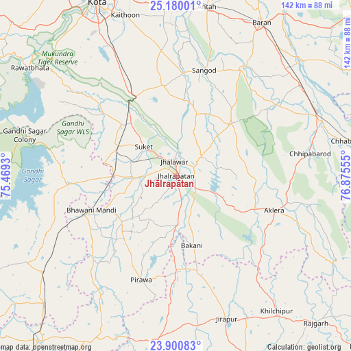
Jhālrapātan GPS coordinates[2]
24° 32' 31.38" North, 76° 10' 20.712" East
| Map corner | latitude | longitude |
|---|---|---|
| Upper-left | 25.18001°, | 75.4693° |
| Center: | 24.54205°, | 76.17242° |
| Lower-right: | 23.90083°, | 76.87555° |
| Map W x H: | 142.2×142.2 km | = 88.4×88.4mi |
| max Lat: | 34.9274° ⇑39.1% North |
| Jhālrapātan: | 24.54205° |
| min Lat: | ⇓60.9% South 8.09008° |
| min Long | Jhālrapātan | max Long |
| 68.82655° | 76.17242° | 96.81° |
| W 28%⇐ | ⇒72% E |
Elevation
Elevation of Jhālrapātan is 318 m = 1043 ft, and this is 22.4 m = 73 ft above average elevation for this country.
| Max E: |
3681 m = 12077 ft | 30.9% |
| Jhālrapātan | 318 m 1043 ft | |
| Avg. | 295.6 m = 970 ft | |
Min E: |
1 m = 3 ft | 69.1% |
See also: India elevation on elevation.city.
Geographical zone
Jhālrapātan is located in North temperate zone (between Tropic of Cancer and the Arctic Circle). Distance of this Northern Tropic circle is 122.9 km =76.4 mi to South.| Distance of | km | miles | from Jhālrapātan |
|---|---|---|---|
| North Pole | 7278.2 | 4522.5 | to North |
| Arctic Circle | 4672.4 | 2903.3 | to North |
| Tropic Cancer | 122.9 | 76.4 | to South |
| Equator | 2728.8 | 1695.6 | to South |


Nearby cities:
15 places around Jhālrapātan: (largest is in red/bold)
• Aklera
42.5 km =26.4 mi,  109°
109°
• Bakāni
29.2 km =18.1 mi,  167°
167°
• Bhawāniganj
36.9 km =22.9 mi,  247°
247°
• Bhānpura
43.2 km =26.8 mi,  265°
265°
• Chechat
38.4 km =23.9 mi,  310°
310°
• Jhālāwār
6.1 km =3.8 mi,  352°
352°
• Khānpur
31 km =19.3 mi,  46°
46°
• Māchalpur
48.3 km =30 mi,  162°
162°
• Pirāwa
45.5 km =28.3 mi,  198°
198°
• Rāmganj Mandi
25.9 km =16.1 mi,  296°
296°
• Sangod
44.3 km =27.5 mi,  15°
15°
• Suket
17.6 km =10.9 mi, 311°
• Sunel
29 km =18 mi,  228°
228°
• Susner
66.7 km =41.4 mi,  187°
187°
• Udpura
29.2 km =18.1 mi,  316°
316°
Sources, notices
• [Note1] Compared only with cities in India existing in our database
• [Src1] Map data: © OpenStreetMap contributors (CC-BY-SA)
• [Src2] Other city data from geonames.org with taken over terms of usage.
• [Src3] Geographical zone / Annual Mean Temperature by Robert A. Rohde @ Wikipedia
