Jhālāwār geodata
Jhālāwār (Rajasthan) is a populated place; located in India in Asia/Kolkata (GMT+5.5) time zone. With population of 51,884 people, there are 859 cities with bigger population in this country. Compared to other cities in India, 61.2% of cities are located further ↓South; 72% of cities are located further →East and 69.5% of cities have lower elevation than Jhālāwār. Note1


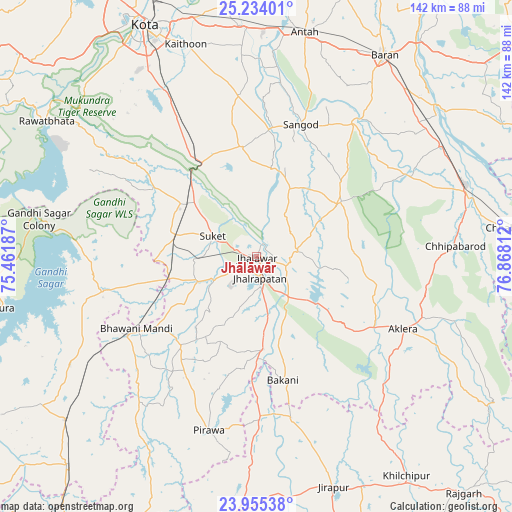
Jhālāwār GPS coordinates[2]
24° 35' 46.788" North, 76° 9' 53.964" East
| Map corner | latitude | longitude |
|---|---|---|
| Upper-left | 25.23401°, | 75.46187° |
| Center: | 24.59633°, | 76.16499° |
| Lower-right: | 23.95538°, | 76.86812° |
| Map W x H: | 142.2×142.2 km | = 88.4×88.4mi |
| max Lat: | 34.9274° ⇑38.8% North |
| Jhālāwār: | 24.59633° |
| min Lat: | ⇓61.2% South 8.09008° |
| min Long | Jhālāwār | max Long |
| 68.82655° | 76.16499° | 96.81° |
| W 28%⇐ | ⇒72% E |
Elevation
Elevation of Jhālāwār is 322 m = 1056 ft, and this is 26.4 m = 87 ft above average elevation for this country.
| Max E: |
3681 m = 12077 ft | 30.5% |
| Jhālāwār | 322 m 1056 ft | |
| Avg. | 295.6 m = 970 ft | |
Min E: |
1 m = 3 ft | 69.5% |
See also: Jhālāwār elevation on elevation.city.
Geographical zone
Jhālāwār is located in North temperate zone (between Tropic of Cancer and the Arctic Circle). Distance of this Northern Tropic circle is 128.9 km =80.1 mi to South.| Distance of | km | miles | from Jhālāwār |
|---|---|---|---|
| North Pole | 7272.2 | 4518.7 | to North |
| Arctic Circle | 4666.3 | 2899.5 | to North |
| Tropic Cancer | 128.9 | 80.1 | to South |
| Equator | 2734.9 | 1699.4 | to South |


Nearby cities:
15 places around Jhālāwār: (largest is in red/bold)
• Aklera
45.5 km =28.3 mi,  116°
116°
• Anta
63.1 km =39.2 mi,  12°
12°
• Bakāni
35.2 km =21.9 mi,  168°
168°
• Bhawāniganj
38.9 km =24.2 mi,  238°
238°
• Bhānpura
43.3 km =26.9 mi,  257°
257°
• Chechat
34.2 km =21.3 mi,  303°
303°
• Jhālrapātan
6.1 km =3.8 mi, 172°
• Khānpur
27.8 km =17.3 mi,  57°
57°
• Māchalpur
54.3 km =33.7 mi,  163°
163°
• Pirāwa
51 km =31.7 mi,  195°
195°
• Rāmganj Mandi
23.1 km =14.4 mi,  283°
283°
• Sangod
38.8 km =24.1 mi,  18°
18°
• Suket
13.6 km =8.5 mi,  293°
293°
• Sunel
32.7 km =20.3 mi,  219°
219°
• Udpura
24.5 km =15.2 mi,  308°
308°
Sources, notices
• [Note1] Compared only with cities in India existing in our database
• [Src1] Map data: © OpenStreetMap contributors (CC-BY-SA)
• [Src2] Other city data from geonames.org with taken over terms of usage.
• [Src3] Geographical zone / Annual Mean Temperature by Robert A. Rohde @ Wikipedia
