Udpura geodata
Udpura (Rajasthan) is a populated place; located in India in Asia/Kolkata (GMT+5.5) time zone. With population of 10,014 people, there are 2939 cities with bigger population in this country. Compared to other cities in India, 62% of cities are located further ↓South; 73.8% of cities are located further →East and 71.2% of cities have lower elevation than Udpura. Note1


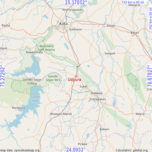
Udpura GPS coordinates[2]
24° 44' 0.78" North, 75° 58' 30.504" East
| Map corner | latitude | longitude |
|---|---|---|
| Upper-left | 25.37052°, | 75.27202° |
| Center: | 24.73355°, | 75.97514° |
| Lower-right: | 24.0933°, | 76.67827° |
| Map W x H: | 142×142 km | = 88.2×88.2mi |
| max Lat: | 34.9274° ⇑38% North |
| Udpura: | 24.73355° |
| min Lat: | ⇓62% South 8.09008° |
| min Long | Udpura | max Long |
| 68.82655° | 75.97514° | 96.81° |
| W 26.2%⇐ | ⇒73.8% E |
Elevation
Elevation of Udpura is 338 m = 1109 ft, and this is 42.4 m = 139 ft above average elevation for this country.
| Max E: |
3681 m = 12077 ft | 28.8% |
| Udpura | 338 m 1109 ft | |
| Avg. | 295.6 m = 970 ft | |
Min E: |
1 m = 3 ft | 71.2% |
See also: India elevation on elevation.city.
Geographical zone
Udpura is located in North temperate zone (between Tropic of Cancer and the Arctic Circle). Distance of this Northern Tropic circle is 144.2 km =89.6 mi to South.| Distance of | km | miles | from Udpura |
|---|---|---|---|
| North Pole | 7256.9 | 4509.2 | to North |
| Arctic Circle | 4651.1 | 2890.1 | to North |
| Tropic Cancer | 144.2 | 89.6 | to South |
| Equator | 2750.1 | 1708.8 | to South |


Nearby cities:
15 places around Udpura: (largest is in red/bold)
• Anta
56.7 km =35.2 mi,  35°
35°
• Bakāni
56.4 km =35 mi,  151°
151°
• Bhawāniganj
38 km =23.6 mi,  201°
201°
• Bhānpura
33.7 km =20.9 mi,  223°
223°
• Chechat
10 km =6.2 mi,  291°
291°
• Jhālrapātan
29.2 km =18.1 mi,  136°
136°
• Jhālāwār
24.5 km =15.2 mi,  128°
128°
• Khānpur
42.5 km =26.4 mi,  90°
90°
• Kota
51.8 km =32.2 mi,  344°
344°
• Rāmganj Mandi
10.2 km =6.3 mi, 198°
• Rāmpura
61.7 km =38.3 mi,  241°
241°
• Rāwatbhāta
44.4 km =27.6 mi,  299°
299°
• Sangod
38.1 km =23.7 mi,  55°
55°
• Suket
11.8 km =7.3 mi, 145°
• Sunel
40.4 km =25.1 mi,  182°
182°
Sources, notices
• [Note1] Compared only with cities in India existing in our database
• [Src1] Map data: © OpenStreetMap contributors (CC-BY-SA)
• [Src2] Other city data from geonames.org with taken over terms of usage.
• [Src3] Geographical zone / Annual Mean Temperature by Robert A. Rohde @ Wikipedia
