Ghoga geodata
Ghoga (Bihar) is a populated place; located in India in Asia/Kolkata (GMT+5.5) time zone. With population of 3,766 people, there are 3387 cities with bigger population in this country. Compared to other cities in India, 64.6% of cities are located further ↓South; 89.5% of cities are located further ←West and 82.1% of cities have higher elevation than Ghoga. Note1


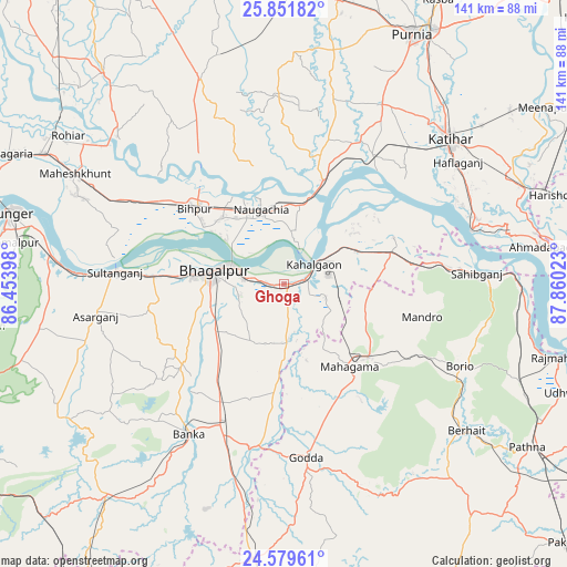
Ghoga GPS coordinates[2]
25° 13' 2.568" North, 87° 9' 25.56" East
| Map corner | latitude | longitude |
|---|---|---|
| Upper-left | 25.85182°, | 86.45398° |
| Center: | 25.21738°, | 87.1571° |
| Lower-right: | 24.57961°, | 87.86023° |
| Map W x H: | 141.5×141.5 km | = 87.9×87.9mi |
| max Lat: | 34.9274° ⇑35.4% North |
| Ghoga: | 25.21738° |
| min Lat: | ⇓64.6% South 8.09008° |
| min Long | Ghoga | max Long |
| 68.82655° | 87.1571° | 96.81° |
| W 89.5%⇐ | ⇒10.5% E |
Elevation
Elevation of Ghoga is 40 m = 131 ft, and this is 255.6 m = 839 ft below average elevation for this country.
| Max E: |
3681 m = 12077 ft | 82.1% |
| Avg. | 295.6 m = 970 ft | |
| Ghoga | 40 m = 131 ft | |
Min E: |
1 m = 3 ft | 17.9% |
See also: India elevation on elevation.city.
Geographical zone
Ghoga is located in North temperate zone (between Tropic of Cancer and the Arctic Circle). Distance of this Northern Tropic circle is 198 km =123 mi to South.| Distance of | km | miles | from Ghoga |
|---|---|---|---|
| North Pole | 7203.2 | 4475.9 | to North |
| Arctic Circle | 4597.3 | 2856.6 | to North |
| Tropic Cancer | 198 | 123 | to South |
| Equator | 2803.9 | 1742.3 | to South |


Nearby cities:
15 places around Ghoga: (largest is in red/bold)
• Amarpur
32.4 km =20.1 mi,  232°
232°
• Asarganj
47.9 km =29.8 mi,  261°
261°
• Bariārpur
58.9 km =36.6 mi,  277°
277°
• Bhāgalpur
18.9 km =11.7 mi, 279°
• Bihārīganj
59.9 km =37.2 mi,  343°
343°
• Bānka
44.2 km =27.5 mi,  212°
212°
• Colgong
9.2 km =5.7 mi,  56°
56°
• Godda
43.8 km =27.2 mi,  172°
172°
• Jamālpur
68 km =42.3 mi, 278°
• Katihar
54.8 km =34.1 mi,  49°
49°
• Kharagpur
61.4 km =38.2 mi, 260°
• Manihāri
48.5 km =30.1 mi,  73°
73°
• Naugachhia
19.9 km =12.4 mi, 342°
• Purnia
70.1 km =43.6 mi,  27°
27°
• Sāhibganj
48.1 km =29.9 mi,  86°
86°
Sources, notices
• [Note1] Compared only with cities in India existing in our database
• [Src1] Map data: © OpenStreetMap contributors (CC-BY-SA)
• [Src2] Other city data from geonames.org with taken over terms of usage.
• [Src3] Geographical zone / Annual Mean Temperature by Robert A. Rohde @ Wikipedia
