Naugachhia geodata
Naugachhia (Bihar) is a populated place; located in India in Asia/Kolkata (GMT+5.5) time zone. With population of 41,247 people, there are 1071 cities with bigger population in this country. Compared to other cities in India, 65.9% of cities are located further ↓South; 89.5% of cities are located further ←West and 82.3% of cities have higher elevation than Naugachhia. Note1


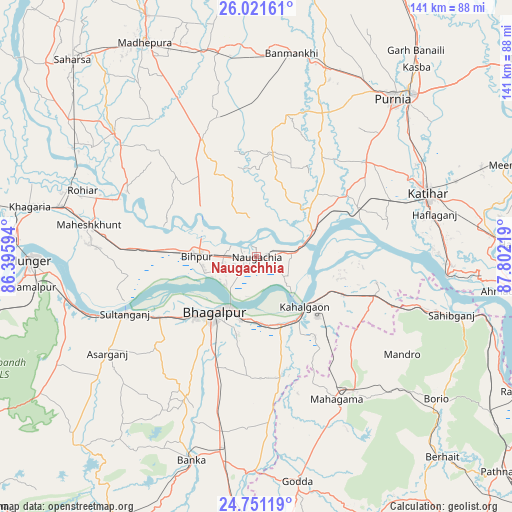
Naugachhia GPS coordinates[2]
25° 23' 17.052" North, 87° 5' 56.616" East
| Map corner | latitude | longitude |
|---|---|---|
| Upper-left | 26.02161°, | 86.39594° |
| Center: | 25.38807°, | 87.09906° |
| Lower-right: | 24.75119°, | 87.80219° |
| Map W x H: | 141.3×141.3 km | = 87.8×87.8mi |
| max Lat: | 34.9274° ⇑34.1% North |
| Naugachhia: | 25.38807° |
| min Lat: | ⇓65.9% South 8.09008° |
| min Long | Naugachhia | max Long |
| 68.82655° | 87.09906° | 96.81° |
| W 89.5%⇐ | ⇒10.5% E |
Elevation
Elevation of Naugachhia is 39 m = 128 ft, and this is 256.6 m = 842 ft below average elevation for this country.
| Max E: |
3681 m = 12077 ft | 82.3% |
| Avg. | 295.6 m = 970 ft | |
| Naugachhia | 39 m = 128 ft | |
Min E: |
1 m = 3 ft | 17.7% |
See also: Naugachhia elevation on elevation.city.
Geographical zone
Naugachhia is located in North temperate zone (between Tropic of Cancer and the Arctic Circle). Distance of this Northern Tropic circle is 217 km =134.8 mi to South.| Distance of | km | miles | from Naugachhia |
|---|---|---|---|
| North Pole | 7184.2 | 4464.1 | to North |
| Arctic Circle | 4578.3 | 2844.8 | to North |
| Tropic Cancer | 217 | 134.8 | to South |
| Equator | 2822.9 | 1754.1 | to South |


Nearby cities:
15 places around Naugachhia: (largest is in red/bold)
• Amarpur
43.5 km =27 mi,  207°
207°
• Asarganj
49.2 km =30.6 mi,  237°
237°
• Banmankhi
56.5 km =35.1 mi,  9°
9°
• Bariārpur
53.7 km =33.4 mi,  258°
258°
• Bhāgalpur
20.5 km =12.7 mi,  218°
218°
• Bihārīganj
40.1 km =24.9 mi,  343°
343°
• Bānka
59.1 km =36.7 mi,  197°
197°
• Colgong
19.3 km =12 mi,  135°
135°
• Ghoga
19.9 km =12.4 mi,  162°
162°
• Jamālpur
61.9 km =38.5 mi, 262°
• Katihar
50.2 km =31.2 mi,  70°
70°
• Manihāri
52.6 km =32.7 mi,  95°
95°
• Murlīganj
57.5 km =35.7 mi,  349°
349°
• Purnia
57.5 km =35.7 mi,  40°
40°
• Sāhibganj
56.2 km =34.9 mi,  106°
106°
Sources, notices
• [Note1] Compared only with cities in India existing in our database
• [Src1] Map data: © OpenStreetMap contributors (CC-BY-SA)
• [Src2] Other city data from geonames.org with taken over terms of usage.
• [Src3] Geographical zone / Annual Mean Temperature by Robert A. Rohde @ Wikipedia
