Sagauli geodata
Sagauli (Bihar) is a populated place; located in India in Asia/Kolkata (GMT+5.5) time zone. With population of 34,622 people, there are 1255 cities with bigger population in this country. Compared to other cities in India, 76.6% of cities are located further ↓South; 83.6% of cities are located further ←West and 73.7% of cities have higher elevation than Sagauli. Note1


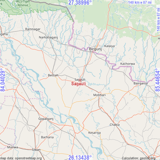
Sagauli GPS coordinates[2]
26° 45' 50.04" North, 84° 44' 36.276" East
| Map corner | latitude | longitude |
|---|---|---|
| Upper-left | 27.38996°, | 84.04029° |
| Center: | 26.7639°, | 84.74341° |
| Lower-right: | 26.13438°, | 85.44654° |
| Map W x H: | 139.6×139.6 km | = 86.7×86.7mi |
| max Lat: | 34.9274° ⇑23.4% North |
| Sagauli: | 26.7639° |
| min Lat: | ⇓76.6% South 8.09008° |
| min Long | Sagauli | max Long |
| 68.82655° | 84.74341° | 96.81° |
| W 83.6%⇐ | ⇒16.4% E |
Elevation
Elevation of Sagauli is 75 m = 246 ft, and this is 220.6 m = 724 ft below average elevation for this country.
| Max E: |
3681 m = 12077 ft | 73.7% |
| Avg. | 295.6 m = 970 ft | |
| Sagauli | 75 m = 246 ft | |
Min E: |
1 m = 3 ft | 26.3% |
See also: India elevation on elevation.city.
Geographical zone
Sagauli is located in North temperate zone (between Tropic of Cancer and the Arctic Circle). Distance of this Northern Tropic circle is 369.9 km =229.8 mi to South.| Distance of | km | miles | from Sagauli |
|---|---|---|---|
| North Pole | 7031.2 | 4369 | to North |
| Arctic Circle | 4425.3 | 2749.8 | to North |
| Tropic Cancer | 369.9 | 229.8 | to South |
| Equator | 2975.9 | 1849.1 | to South |


Nearby cities:
15 places around Sagauli: (largest is in red/bold)
• Bagaha
74.7 km =46.4 mi,  299°
299°
• Bairāgnia
52.7 km =32.7 mi,  92°
92°
• Barauli
45.3 km =28.1 mi,  200°
200°
• Belsand
74.4 km =46.2 mi,  118°
118°
• Bettiah
24.2 km =15 mi,  280°
280°
• Chākia
49 km =30.4 mi,  142°
142°
• Dhāka
43.2 km =26.8 mi,  103°
103°
• Gopālganj
44.7 km =27.8 mi,  222°
222°
• Mahārājgani
76.5 km =47.5 mi, 198°
• Mothīhāri
21.4 km =13.3 mi,  126°
126°
• Raxaul
26.3 km =16.3 mi,  23°
23°
• Rāmnagar
60.9 km =37.8 mi,  316°
316°
• Sheohar
61.3 km =38.1 mi, 116°
• Siwān
71.6 km =44.5 mi,  212°
212°
• Sītāmarhi
76.6 km =47.6 mi, 104°
Sources, notices
• [Note1] Compared only with cities in India existing in our database
• [Src1] Map data: © OpenStreetMap contributors (CC-BY-SA)
• [Src2] Other city data from geonames.org with taken over terms of usage.
• [Src3] Geographical zone / Annual Mean Temperature by Robert A. Rohde @ Wikipedia
