Bettiah geodata
Bettiah (Bihar) is a populated place; located in India in Asia/Kolkata (GMT+5.5) time zone. With population of 127,008 people, there are 346 cities with bigger population in this country. Compared to other cities in India, 77% of cities are located further ↓South; 83.1% of cities are located further ←West and 72.1% of cities have higher elevation than Bettiah. Note1


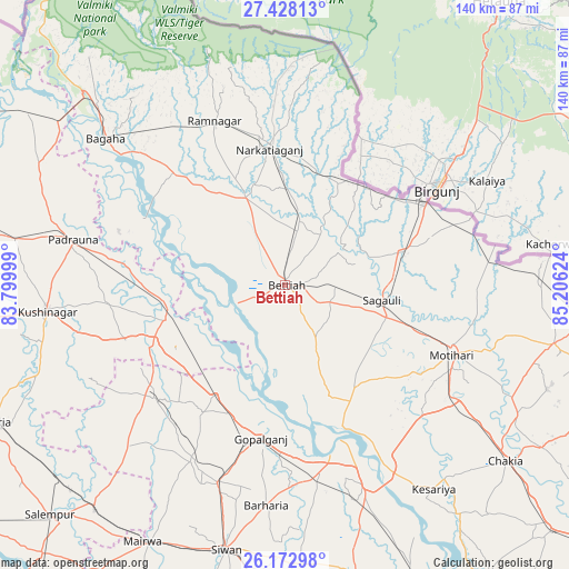
Bettiah GPS coordinates[2]
26° 48' 8.244" North, 84° 30' 11.196" East
| Map corner | latitude | longitude |
|---|---|---|
| Upper-left | 27.42813°, | 83.79999° |
| Center: | 26.80229°, | 84.50311° |
| Lower-right: | 26.17298°, | 85.20624° |
| Map W x H: | 139.6×139.6 km | = 86.7×86.7mi |
| max Lat: | 34.9274° ⇑23% North |
| Bettiah: | 26.80229° |
| min Lat: | ⇓77% South 8.09008° |
| min Long | Bettiah | max Long |
| 68.82655° | 84.50311° | 96.81° |
| W 83.1%⇐ | ⇒16.9% E |
Elevation
Elevation of Bettiah is 84 m = 276 ft, and this is 211.6 m = 694 ft below average elevation for this country.
| Max E: |
3681 m = 12077 ft | 72.1% |
| Avg. | 295.6 m = 970 ft | |
| Bettiah | 84 m = 276 ft | |
Min E: |
1 m = 3 ft | 27.9% |
See also: Bettiah elevation on elevation.city.
Geographical zone
Bettiah is located in North temperate zone (between Tropic of Cancer and the Arctic Circle). Distance of this Northern Tropic circle is 374.2 km =232.5 mi to South.| Distance of | km | miles | from Bettiah |
|---|---|---|---|
| North Pole | 7026.9 | 4366.3 | to North |
| Arctic Circle | 4421 | 2747.1 | to North |
| Tropic Cancer | 374.2 | 232.5 | to South |
| Equator | 2980.1 | 1851.7 | to South |


Nearby cities:
15 places around Bettiah: (largest is in red/bold)
• Bagaha
52.6 km =32.7 mi,  308°
308°
• Barauli
47.6 km =29.6 mi,  169°
169°
• Chākia
69 km =42.9 mi,  128°
128°
• Dhāka
67.4 km =41.9 mi,  102°
102°
• Gopālganj
37.8 km =23.5 mi,  189°
189°
• Hātā
75.5 km =46.9 mi,  264°
264°
• Khada
74.6 km =46.4 mi,  304°
304°
• Mairwa
71.8 km =44.6 mi,  208°
208°
• Mothīhāri
44.5 km =27.7 mi,  112°
112°
• Padrauna
53 km =32.9 mi,  282°
282°
• Raxaul
39.7 km =24.7 mi,  60°
60°
• Rāmkola
66.9 km =41.6 mi, 279°
• Rāmnagar
44 km =27.3 mi,  336°
336°
• Sagauli
24.2 km =15 mi, 100°
• Siwān
66.3 km =41.2 mi, 192°
Sources, notices
• [Note1] Compared only with cities in India existing in our database
• [Src1] Map data: © OpenStreetMap contributors (CC-BY-SA)
• [Src2] Other city data from geonames.org with taken over terms of usage.
• [Src3] Geographical zone / Annual Mean Temperature by Robert A. Rohde @ Wikipedia
