Nānpāra geodata
Nānpāra (Uttar Pradesh) is a populated place; located in India in Asia/Kolkata (GMT+5.5) time zone. With population of 46,280 people, there are 956 cities with bigger population in this country. Compared to other cities in India, 83.8% of cities are located further ↓South; 74.6% of cities are located further ←West and 61.9% of cities have higher elevation than Nānpāra. Note1


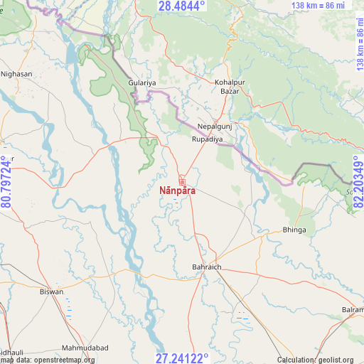
Nānpāra GPS coordinates[2]
27° 51' 52.524" North, 81° 30' 1.296" East
| Map corner | latitude | longitude |
|---|---|---|
| Upper-left | 28.4844°, | 80.79724° |
| Center: | 27.86459°, | 81.50036° |
| Lower-right: | 27.24122°, | 82.20349° |
| Map W x H: | 138.2×138.2 km | = 85.9×85.9mi |
| max Lat: | 34.9274° ⇑16.2% North |
| Nānpāra: | 27.86459° |
| min Lat: | ⇓83.8% South 8.09008° |
| min Long | Nānpāra | max Long |
| 68.82655° | 81.50036° | 96.81° |
| W 74.6%⇐ | ⇒25.4% E |
Elevation
Elevation of Nānpāra is 138 m = 453 ft, and this is 157.6 m = 517 ft below average elevation for this country.
| Max E: |
3681 m = 12077 ft | 61.9% |
| Avg. | 295.6 m = 970 ft | |
| Nānpāra | 138 m = 453 ft | |
Min E: |
1 m = 3 ft | 38.1% |
See also: Nānpāra elevation on elevation.city.
Geographical zone
Nānpāra is located in North temperate zone (between Tropic of Cancer and the Arctic Circle). Distance of this Northern Tropic circle is 492.3 km =305.9 mi to South.| Distance of | km | miles | from Nānpāra |
|---|---|---|---|
| North Pole | 6908.8 | 4292.9 | to North |
| Arctic Circle | 4302.9 | 2673.7 | to North |
| Tropic Cancer | 492.3 | 305.9 | to South |
| Equator | 3098.3 | 1925.2 | to South |


Nearby cities:
15 places around Nānpāra: (largest is in red/bold)
• Amethi
47.4 km =29.5 mi,  290°
290°
• Bahraigh
33.6 km =20.9 mi,  163°
163°
• Bhinga
46.3 km =28.8 mi,  112°
112°
• Biswān
64.4 km =40 mi,  230°
230°
• Dhaurahra
43 km =26.7 mi, 290°
• Fatehpur
82.1 km =51 mi,  200°
200°
• Ikauna
59.2 km =36.8 mi,  128°
128°
• Jarwal
78.1 km =48.5 mi,  177°
177°
• Katra
65.2 km =40.5 mi, 127°
• Khairābād
82.5 km =51.3 mi,  242°
242°
• Khargupur
72.5 km =45 mi,  138°
138°
• Kheri
69.2 km =43 mi,  273°
273°
• Lakhīmpur
71.5 km =44.4 mi,  277°
277°
• Lāharpur
61.3 km =38.1 mi,  253°
253°
• Mahmudābād
74 km =46 mi,  210°
210°
Sources, notices
• [Note1] Compared only with cities in India existing in our database
• [Src1] Map data: © OpenStreetMap contributors (CC-BY-SA)
• [Src2] Other city data from geonames.org with taken over terms of usage.
• [Src3] Geographical zone / Annual Mean Temperature by Robert A. Rohde @ Wikipedia
