Mawet geodata
Mawet (Sulaymaniyah) is a seat of a second-order administrative division; located in Iraq in Asia/Baghdad (GMT+3) time zone. In our database, there are 71 cities with bigger population. Compared to other cities in Iraq, 71.1% of cities are located further ↓South; 76.1% of cities are located further ←West and 91.5% of cities have lower elevation than Mawet. Note1


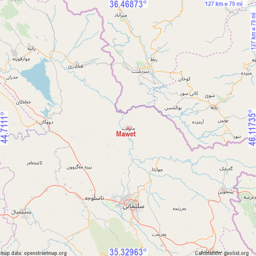
Mawet GPS coordinates[2]
35° 54' 4.428" North, 45° 24' 51.192" East
| Map corner | latitude | longitude |
|---|---|---|
| Upper-left | 36.46873°, | 44.7111° |
| Center: | 35.90123°, | 45.41422° |
| Lower-right: | 35.32963°, | 46.11735° |
| Map W x H: | 126.7×126.7 km | = 78.7×78.7mi |
| max Lat: | 37.22781° ⇑28.9% North |
| Mawet: | 35.90123° |
| min Lat: | ⇓71.1% South 29.97421° |
| min Long | Mawet | max Long |
| 40.28586° | 45.41422° | 48.47309° |
| W 76.1%⇐ | ⇒23.9% E |
Elevation
Elevation of Mawet is 892 m = 2927 ft, and this is 599 m = 1965 ft above average elevation for this country.
| Max E: |
1316 m = 4318 ft | 8.5% |
| Mawet | 892 m 2927 ft | |
| Avg. | 293 m = 961 ft | |
Min E: |
1 m = 3 ft | 91.5% |
See also: Iraq elevation on elevation.city.
Geographical zone
Mawet is located in North temperate zone (between Tropic of Cancer and the Arctic Circle). Distance of this Northern Tropic circle is 1385.9 km =861.2 mi to South.| Distance of | km | miles | from Mawet |
|---|---|---|---|
| North Pole | 6015.2 | 3737.7 | to North |
| Arctic Circle | 3409.3 | 2118.4 | to North |
| Tropic Cancer | 1385.9 | 861.2 | to South |
| Equator | 3991.8 | 2480.4 | to South |


Nearby cities:
15 places around Mawet: (largest is in red/bold)
• As Sulaymānīyah
37.4 km =23.2 mi,  177°
177°
• Baynjiwayn
57.5 km =35.7 mi,  122°
122°
• Chwarta
24.6 km =15.3 mi,  144°
144°
• Derbendîxan
91.1 km =56.6 mi,  164°
164°
• Dukan
40.8 km =25.4 mi,  274°
274°
• Halshaw
36.9 km =22.9 mi,  337°
337°
• Hayraw
27.7 km =17.2 mi,  334°
334°
• Hīrān
92.7 km =57.6 mi,  296°
296°
• Jamjamāl
66.4 km =41.3 mi,  232°
232°
• Koysinceq
73.5 km =45.7 mi,  285°
285°
• Qeredagh
66.1 km =41.1 mi, 181°
• Qeładizê
40.4 km =25.1 mi,  320°
320°
• Seyid Sadiq
73.4 km =45.6 mi,  146°
146°
• Ḩalabjah al Jadīdah
69.3 km =43.1 mi, 158°
• Ṟaniye
61.9 km =38.5 mi,  309°
309°
Sources, notices
• [Note1] Compared only with cities in Iraq existing in our database
• [Src1] Map data: © OpenStreetMap contributors (CC-BY-SA)
• [Src2] Other city data from geonames.org with taken over terms of usage.
• [Src3] Geographical zone / Annual Mean Temperature by Robert A. Rohde @ Wikipedia
