Chwarta geodata
Chwarta (Sulaymaniyah) is a seat of a second-order administrative division; located in Iraq in Asia/Baghdad (GMT+3) time zone. In our database, there are 71 cities with bigger population. Compared to other cities in Iraq, 69% of cities are located further ↓South; 78.2% of cities are located further ←West and 100% of cities have lower elevation than Chwarta. Note1


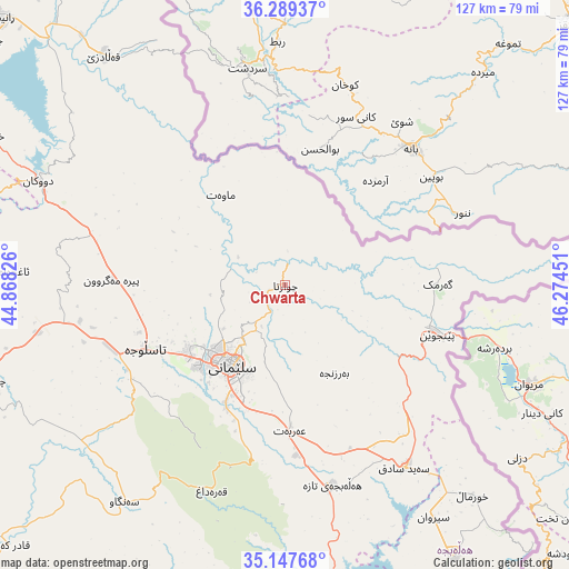
Chwarta GPS coordinates[2]
35° 43' 14.052" North, 45° 34' 16.968" East
| Map corner | latitude | longitude |
|---|---|---|
| Upper-left | 36.28937°, | 44.86826° |
| Center: | 35.72057°, | 45.57138° |
| Lower-right: | 35.14768°, | 46.27451° |
| Map W x H: | 126.9×126.9 km | = 78.9×78.9mi |
| max Lat: | 37.22781° ⇑31% North |
| Chwarta: | 35.72057° |
| min Lat: | ⇓69% South 29.97421° |
| min Long | Chwarta | max Long |
| 40.28586° | 45.57138° | 48.47309° |
| W 78.2%⇐ | ⇒21.8% E |
Elevation
Elevation of Chwarta is 1316 m = 4318 ft, and this is 1023 m = 3356 ft above average elevation for this country.
| Max E: |
1316 m = 4318 ft | 0% |
| Chwarta | 1316 m 4318 ft | |
| Avg. | 293 m = 961 ft | |
Min E: |
1 m = 3 ft | 100% |
See also: Iraq elevation on elevation.city.
Geographical zone
Chwarta is located in North temperate zone (between Tropic of Cancer and the Arctic Circle). Distance of this Northern Tropic circle is 1365.8 km =848.7 mi to South.| Distance of | km | miles | from Chwarta |
|---|---|---|---|
| North Pole | 6035.3 | 3750.2 | to North |
| Arctic Circle | 3429.4 | 2130.9 | to North |
| Tropic Cancer | 1365.8 | 848.7 | to South |
| Equator | 3971.8 | 2468 | to South |


Nearby cities:
15 places around Chwarta: (largest is in red/bold)
• As Sulaymānīyah
21.4 km =13.3 mi,  215°
215°
• Baynjiwayn
35.9 km =22.3 mi,  108°
108°
• Derbendîxan
68.5 km =42.6 mi,  171°
171°
• Dukan
59.6 km =37 mi,  292°
292°
• Halshaw
61.1 km =38 mi,  332°
332°
• Hayraw
52.1 km =32.4 mi, 330°
• Jamjamāl
69.8 km =43.4 mi,  252°
252°
• Koysinceq
94 km =58.4 mi,  295°
295°
• Mawet
24.6 km =15.3 mi,  324°
324°
• Qeredagh
48.8 km =30.3 mi,  199°
199°
• Qeładizê
64.9 km =40.3 mi, 322°
• Seyid Sadiq
48.9 km =30.4 mi,  146°
146°
• Ḩalabjah
71.1 km =44.2 mi, 148°
• Ḩalabjah al Jadīdah
45.8 km =28.5 mi, 166°
• Ṟaniye
85.9 km =53.4 mi,  313°
313°
Sources, notices
• [Note1] Compared only with cities in Iraq existing in our database
• [Src1] Map data: © OpenStreetMap contributors (CC-BY-SA)
• [Src2] Other city data from geonames.org with taken over terms of usage.
• [Src3] Geographical zone / Annual Mean Temperature by Robert A. Rohde @ Wikipedia
