Derbendîxan geodata
Derbendîxan (Sulaymaniyah) is a seat of a second-order administrative division; located in Iraq in Asia/Baghdad (GMT+3) time zone. In our database, there are 71 cities with bigger population. Compared to other cities in Iraq, 57.7% of cities are located further ↓South; 78.9% of cities are located further ←West and 76.8% of cities have lower elevation than Derbendîxan. Note1


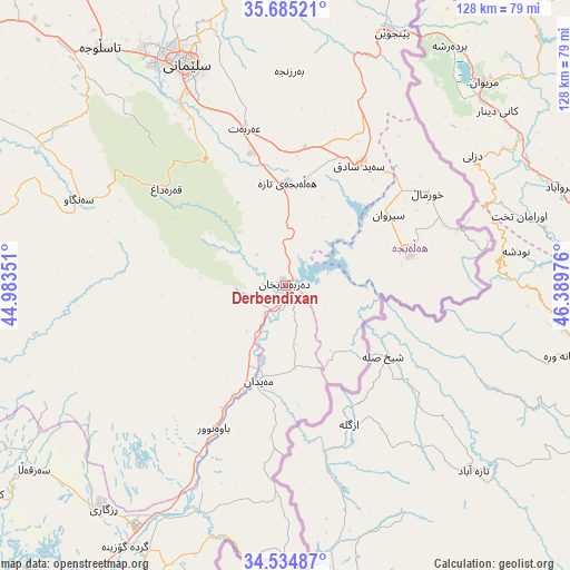
Derbendîxan GPS coordinates[2]
35° 6' 43.452" North, 45° 41' 11.868" East
| Map corner | latitude | longitude |
|---|---|---|
| Upper-left | 35.68521°, | 44.98351° |
| Center: | 35.11207°, | 45.68663° |
| Lower-right: | 34.53487°, | 46.38976° |
| Map W x H: | 127.9×127.9 km | = 79.5×79.5mi |
| max Lat: | 37.22781° ⇑42.3% North |
| Derbendîxan: | 35.11207° |
| min Lat: | ⇓57.7% South 29.97421° |
| min Long | Derbendîxan | max Long |
| 40.28586° | 45.68663° | 48.47309° |
| W 78.9%⇐ | ⇒21.1% E |
Elevation
Elevation of Derbendîxan is 510 m = 1673 ft, and this is 217 m = 712 ft above average elevation for this country.
| Max E: |
1316 m = 4318 ft | 23.2% |
| Derbendîxan | 510 m 1673 ft | |
| Avg. | 293 m = 961 ft | |
Min E: |
1 m = 3 ft | 76.8% |
See also: Iraq elevation on elevation.city.
Geographical zone
Derbendîxan is located in North temperate zone (between Tropic of Cancer and the Arctic Circle). Distance of this Northern Tropic circle is 1298.2 km =806.7 mi to South.| Distance of | km | miles | from Derbendîxan |
|---|---|---|---|
| North Pole | 6103 | 3792.2 | to North |
| Arctic Circle | 3497.1 | 2173 | to North |
| Tropic Cancer | 1298.2 | 806.7 | to South |
| Equator | 3904.1 | 2425.9 | to South |


Nearby cities:
15 places around Derbendîxan: (largest is in red/bold)
• As Sulaymānīyah
55.4 km =34.4 mi,  335°
335°
• Baynjiwayn
61.3 km =38.1 mi,  22°
22°
• Chwarta
68.5 km =42.6 mi,  351°
351°
• Dukan
112 km =69.6 mi,  324°
324°
• Dāqūq
112.6 km =70 mi,  271°
271°
• Jamjamāl
90.4 km =56.2 mi,  301°
301°
• Kelar
63.4 km =39.4 mi,  211°
211°
• Khānaqīn
89.1 km =55.4 mi,  197°
197°
• Kifrī
81.2 km =50.5 mi,  234°
234°
• Mawet
91.1 km =56.6 mi, 344°
• Qeredagh
34.5 km =21.4 mi,  308°
308°
• Seyid Sadiq
31.4 km =19.5 mi,  31°
31°
• Tozkhurmato
99.2 km =61.6 mi,  255°
255°
• Ḩalabjah
28.2 km =17.5 mi,  74°
74°
• Ḩalabjah al Jadīdah
23.1 km =14.4 mi,  0°
0°
Sources, notices
• [Note1] Compared only with cities in Iraq existing in our database
• [Src1] Map data: © OpenStreetMap contributors (CC-BY-SA)
• [Src2] Other city data from geonames.org with taken over terms of usage.
• [Src3] Geographical zone / Annual Mean Temperature by Robert A. Rohde @ Wikipedia
