Ḩalabjah geodata
Ḩalabjah (Sulaymaniyah) is a populated place; located in Iraq in Asia/Baghdad (GMT+3) time zone. With population of 57,333 people, there are 37 cities with bigger population in this country. Compared to other cities in Iraq, 59.2% of cities are located further ↓South; 83.1% of cities are located further ←West and 86.6% of cities have lower elevation than Ḩalabjah. Note1


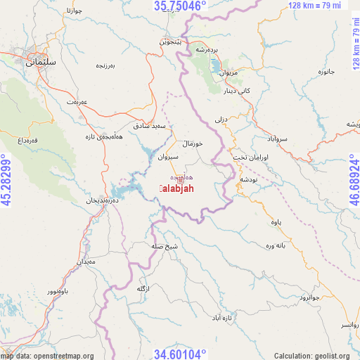
Ḩalabjah GPS coordinates[2]
35° 10' 40.008" North, 45° 59' 9.996" East
| Map corner | latitude | longitude |
|---|---|---|
| Upper-left | 35.75046°, | 45.28299° |
| Center: | 35.17778°, | 45.98611° |
| Lower-right: | 34.60104°, | 46.68924° |
| Map W x H: | 127.8×127.8 km | = 79.4×79.4mi |
| max Lat: | 37.22781° ⇑40.8% North |
| Ḩalabjah: | 35.17778° |
| min Lat: | ⇓59.2% South 29.97421° |
| min Long | Ḩalabjah | max Long |
| 40.28586° | 45.98611° | 48.47309° |
| W 83.1%⇐ | ⇒16.9% E |
Elevation
Elevation of Ḩalabjah is 711 m = 2333 ft, and this is 418 m = 1371 ft above average elevation for this country.
| Max E: |
1316 m = 4318 ft | 13.4% |
| Ḩalabjah | 711 m 2333 ft | |
| Avg. | 293 m = 961 ft | |
Min E: |
1 m = 3 ft | 86.6% |
See also: Ḩalabjah elevation on elevation.city.
Geographical zone
Ḩalabjah is located in North temperate zone (between Tropic of Cancer and the Arctic Circle). Distance of this Northern Tropic circle is 1305.5 km =811.2 mi to South.| Distance of | km | miles | from Ḩalabjah |
|---|---|---|---|
| North Pole | 6095.7 | 3787.7 | to North |
| Arctic Circle | 3489.8 | 2168.5 | to North |
| Tropic Cancer | 1305.5 | 811.2 | to South |
| Equator | 3911.4 | 2430.4 | to South |


Nearby cities:
15 places around Ḩalabjah: (largest is in red/bold)
• As Sulaymānīyah
66.1 km =41.1 mi,  310°
310°
• Baynjiwayn
49.3 km =30.6 mi,  356°
356°
• Chwarta
71.1 km =44.2 mi,  328°
328°
• Derbendîxan
28.2 km =17.5 mi,  254°
254°
• Dukan
124.7 km =77.5 mi, 312°
• Hayraw
123.2 km =76.6 mi, 328°
• Jamjamāl
111.7 km =69.4 mi,  290°
290°
• Kelar
86.3 km =53.6 mi,  224°
224°
• Khānaqīn
107.1 km =66.5 mi,  210°
210°
• Kifrī
108.1 km =67.2 mi,  239°
239°
• Mawet
95.6 km =59.4 mi, 327°
• Qeredagh
56 km =34.8 mi,  284°
284°
• Seyid Sadiq
22.3 km =13.9 mi, 330°
• Tozkhurmato
127.4 km =79.2 mi,  255°
255°
• Ḩalabjah al Jadīdah
31.2 km =19.4 mi,  300°
300°
Sources, notices
• [Note1] Compared only with cities in Iraq existing in our database
• [Src1] Map data: © OpenStreetMap contributors (CC-BY-SA)
• [Src2] Other city data from geonames.org with taken over terms of usage.
• [Src3] Geographical zone / Annual Mean Temperature by Robert A. Rohde @ Wikipedia
