Shiraz geodata
Shiraz (Fars) is a seat of a first-order administrative division; located in Iran in Asia/Tehran (GMT+3.5) time zone. With population of 1,249,942 people, there are 5 cities with bigger population in this country. Compared to other cities in Iran, 84.6% of cities are located further ↑North; 61.7% of cities are located further ←West and 73% of cities have lower elevation than Shiraz. Note1


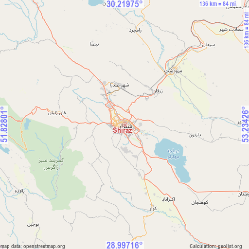
Shiraz GPS coordinates[2]
29° 36' 37.116" North, 52° 31' 52.068" East
| Map corner | latitude | longitude |
|---|---|---|
| Upper-left | 30.21975°, | 51.82801° |
| Center: | 29.61031°, | 52.53113° |
| Lower-right: | 28.99716°, | 53.23426° |
| Map W x H: | 135.9×135.9 km | = 84.4×84.4mi |
| max Lat: | 39.6482° ⇑84.6% North |
| Shiraz: | 29.61031° |
| min Lat: | ⇓15.4% South 25.2919° |
| min Long | Shiraz | max Long |
| 44.38416° | 52.53113° | 61.9965° |
| W 61.7%⇐ | ⇒38.3% E |
Elevation
Elevation of Shiraz is 1545 m = 5069 ft, and this is 496 m = 1627 ft above average elevation for this country.
| Max E: |
2564 m = 8412 ft | 27% |
| Shiraz | 1545 m 5069 ft | |
| Avg. | 1049 m = 3442 ft | |
Min E: |
-24 m = -79 ft | 73% |
See also: Shiraz elevation on elevation.city.
Geographical zone
Shiraz is located in North temperate zone (between Tropic of Cancer and the Arctic Circle). Distance of this Northern Tropic circle is 686.4 km =426.5 mi to South.| Distance of | km | miles | from Shiraz |
|---|---|---|---|
| North Pole | 6714.7 | 4172.3 | to North |
| Arctic Circle | 4108.8 | 2553.1 | to North |
| Tropic Cancer | 686.4 | 426.5 | to South |
| Equator | 3292.4 | 2045.8 | to South |


Nearby cities:
15 places around Shiraz: (largest is in red/bold)
• Akbarābād
47.1 km =29.3 mi,  149°
149°
• Arsanjān
82.2 km =51.1 mi,  65°
65°
• Farāshband
92.6 km =57.5 mi,  207°
207°
• Fīrūzābād
85.3 km =53 mi,  177°
177°
• Kavār
47.6 km =29.6 mi,  161°
161°
• Kherāmeh
76.5 km =47.5 mi,  99°
99°
• Kāzerūn
84.8 km =52.7 mi,  270°
270°
• Marvdasht
39.3 km =24.4 mi,  41°
41°
• Maşīrī
120.2 km =74.7 mi,  306°
306°
• Nūrābād
112.3 km =69.8 mi,  299°
299°
• Pāsārgād
90.8 km =56.4 mi, 43°
• Sarvestān
76.5 km =47.5 mi,  119°
119°
• Sa‘ādat Shahr
78.1 km =48.5 mi,  48°
48°
• Sepīdān
89.5 km =55.6 mi,  323°
323°
• Şafāshahr
128.5 km =79.8 mi,  29°
29°
Sources, notices
• [Note1] Compared only with cities in Iran existing in our database
• [Src1] Map data: © OpenStreetMap contributors (CC-BY-SA)
• [Src2] Other city data from geonames.org with taken over terms of usage.
• [Src3] Geographical zone / Annual Mean Temperature by Robert A. Rohde @ Wikipedia
