Sarvestān geodata
Sarvestān (Fars) is a seat of a second-order administrative division; located in Iran in Asia/Tehran (GMT+3.5) time zone. In our database, there are 232 cities with bigger population. Compared to other cities in Iran, 86.2% of cities are located further ↑North; 67.6% of cities are located further ←West and 72.8% of cities have lower elevation than Sarvestān. Note1


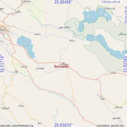
Sarvestān GPS coordinates[2]
29° 16' 24.6" North, 53° 13' 13.08" East
| Map corner | latitude | longitude |
|---|---|---|
| Upper-left | 29.88498°, | 52.51718° |
| Center: | 29.2735°, | 53.2203° |
| Lower-right: | 28.65834°, | 53.92343° |
| Map W x H: | 136.4×136.4 km | = 84.8×84.8mi |
| max Lat: | 39.6482° ⇑86.2% North |
| Sarvestān: | 29.2735° |
| min Lat: | ⇓13.8% South 25.2919° |
| min Long | Sarvestān | max Long |
| 44.38416° | 53.2203° | 61.9965° |
| W 67.6%⇐ | ⇒32.4% E |
Elevation
Elevation of Sarvestān is 1542 m = 5059 ft, and this is 493 m = 1617 ft above average elevation for this country.
| Max E: |
2564 m = 8412 ft | 27.2% |
| Sarvestān | 1542 m 5059 ft | |
| Avg. | 1049 m = 3442 ft | |
Min E: |
-24 m = -79 ft | 72.8% |
See also: Iran elevation on elevation.city.
Geographical zone
Sarvestān is located in North temperate zone (between Tropic of Cancer and the Arctic Circle). Distance of this Northern Tropic circle is 649 km =403.3 mi to South.| Distance of | km | miles | from Sarvestān |
|---|---|---|---|
| North Pole | 6752.2 | 4195.6 | to North |
| Arctic Circle | 4146.3 | 2576.4 | to North |
| Tropic Cancer | 649 | 403.3 | to South |
| Equator | 3254.9 | 2022.5 | to South |


Nearby cities:
15 places around Sarvestān: (largest is in red/bold)
• Akbarābād
42.9 km =26.7 mi,  265°
265°
• Arsanjān
71.5 km =44.4 mi,  6°
6°
• Estahbān
81.4 km =50.6 mi,  101°
101°
• Farāshband
118.5 km =73.6 mi,  247°
247°
• Fasā
55.8 km =34.7 mi,  131°
131°
• Fīrūzābād
79.2 km =49.2 mi,  232°
232°
• Jahrom
92.2 km =57.3 mi,  158°
158°
• Kavār
52 km =32.3 mi,  261°
261°
• Kherāmeh
26.6 km =16.5 mi,  19°
19°
• Marvdasht
78.1 km =48.5 mi,  328°
328°
• Neyrīz
107.8 km =67 mi,  94°
94°
• Pāsārgād
103.3 km =64.2 mi,  357°
357°
• Qīr
89.8 km =55.8 mi,  191°
191°
• Sa‘ādat Shahr
90 km =55.9 mi,  354°
354°
• Shiraz
76.5 km =47.5 mi,  299°
299°
Sources, notices
• [Note1] Compared only with cities in Iran existing in our database
• [Src1] Map data: © OpenStreetMap contributors (CC-BY-SA)
• [Src2] Other city data from geonames.org with taken over terms of usage.
• [Src3] Geographical zone / Annual Mean Temperature by Robert A. Rohde @ Wikipedia
