Farāshband geodata
Farāshband (Fars) is a seat of a second-order administrative division; located in Iran in Asia/Tehran (GMT+3.5) time zone. In our database, there are 232 cities with bigger population. Compared to other cities in Iran, 89.3% of cities are located further ↑North; 59.6% of cities are located further ←West and 67.1% of cities have higher elevation than Farāshband. Note1


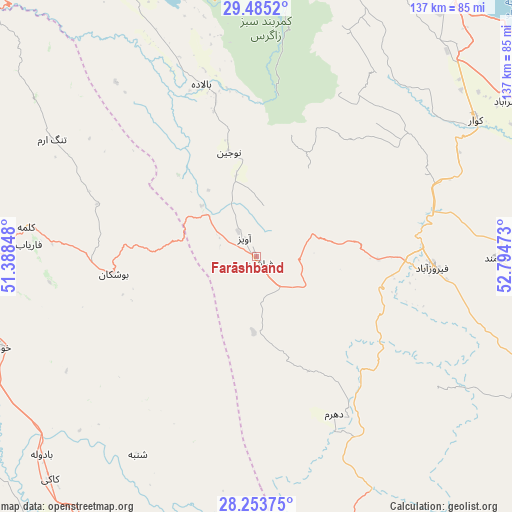
Farāshband GPS coordinates[2]
28° 52' 16.68" North, 52° 5' 29.76" East
| Map corner | latitude | longitude |
|---|---|---|
| Upper-left | 29.4852°, | 51.38848° |
| Center: | 28.8713°, | 52.0916° |
| Lower-right: | 28.25375°, | 52.79473° |
| Map W x H: | 136.9×136.9 km | = 85.1×85.1mi |
| max Lat: | 39.6482° ⇑89.3% North |
| Farāshband: | 28.8713° |
| min Lat: | ⇓10.7% South 25.2919° |
| min Long | Farāshband | max Long |
| 44.38416° | 52.0916° | 61.9965° |
| W 59.6%⇐ | ⇒40.4% E |
Elevation
Elevation of Farāshband is 799 m = 2621 ft, and this is 250 m = 820 ft below average elevation for this country.
| Max E: |
2564 m = 8412 ft | 67.1% |
| Avg. | 1049 m = 3442 ft | |
| Farāshband | 799 m = 2621 ft | |
Min E: |
-24 m = -79 ft | 32.9% |
See also: Iran elevation on elevation.city.
Geographical zone
Farāshband is located in North temperate zone (between Tropic of Cancer and the Arctic Circle). Distance of this Northern Tropic circle is 604.3 km =375.5 mi to South.| Distance of | km | miles | from Farāshband |
|---|---|---|---|
| North Pole | 6796.9 | 4223.4 | to North |
| Arctic Circle | 4191 | 2604.2 | to North |
| Tropic Cancer | 604.3 | 375.5 | to South |
| Equator | 3210.2 | 1994.7 | to South |


Nearby cities:
15 places around Farāshband: (largest is in red/bold)
• Ahram
79.6 km =49.5 mi,  270°
270°
• Akbarābād
78.8 km =49 mi,  58°
58°
• Borāzjān
95.7 km =59.5 mi,  297°
297°
• Bushehr
122.6 km =76.2 mi,  275°
275°
• Deyr
115.7 km =71.9 mi,  187°
187°
• Fīrūzābād
46.8 km =29.1 mi,  93°
93°
• Jam
118.2 km =73.4 mi,  168°
168°
• Kangān
115.4 km =71.7 mi,  181°
181°
• Kavār
69 km =42.9 mi, 57°
• Khowrmūj
73.4 km =45.6 mi,  250°
250°
• Kāzerūn
93.4 km =58 mi,  332°
332°
• Marvdasht
131.1 km =81.5 mi,  31°
31°
• Qīr
101.6 km =63.1 mi,  115°
115°
• Sarvestān
118.5 km =73.6 mi,  67°
67°
• Shiraz
92.6 km =57.5 mi, 27°
Sources, notices
• [Note1] Compared only with cities in Iran existing in our database
• [Src1] Map data: © OpenStreetMap contributors (CC-BY-SA)
• [Src2] Other city data from geonames.org with taken over terms of usage.
• [Src3] Geographical zone / Annual Mean Temperature by Robert A. Rohde @ Wikipedia
