Nūrābād geodata
Nūrābād (Fars) is a seat of a second-order administrative division; located in Iran in Asia/Tehran (GMT+3.5) time zone. With population of 64,041 people, there are 101 cities with bigger population in this country. Compared to other cities in Iran, 82.5% of cities are located further ↑North; 53.3% of cities are located further ←West and 61.2% of cities have higher elevation than Nūrābād. Note1


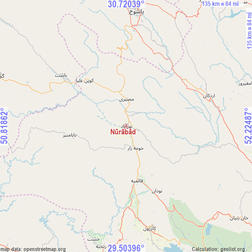
Nūrābād GPS coordinates[2]
30° 6' 50.58" North, 51° 31' 18.264" East
| Map corner | latitude | longitude |
|---|---|---|
| Upper-left | 30.72039°, | 50.81862° |
| Center: | 30.11405°, | 51.52174° |
| Lower-right: | 29.50396°, | 52.22487° |
| Map W x H: | 135.3×135.3 km | = 84.1×84.1mi |
| max Lat: | 39.6482° ⇑82.5% North |
| Nūrābād: | 30.11405° |
| min Lat: | ⇓17.5% South 25.2919° |
| min Long | Nūrābād | max Long |
| 44.38416° | 51.52174° | 61.9965° |
| W 53.3%⇐ | ⇒46.7% E |
Elevation
Elevation of Nūrābād is 951 m = 3120 ft, and this is 98 m = 322 ft below average elevation for this country.
| Max E: |
2564 m = 8412 ft | 61.2% |
| Avg. | 1049 m = 3442 ft | |
| Nūrābād | 951 m = 3120 ft | |
Min E: |
-24 m = -79 ft | 38.8% |
See also: Nūrābād elevation on elevation.city.
Geographical zone
Nūrābād is located in North temperate zone (between Tropic of Cancer and the Arctic Circle). Distance of this Northern Tropic circle is 742.4 km =461.3 mi to South.| Distance of | km | miles | from Nūrābād |
|---|---|---|---|
| North Pole | 6658.7 | 4137.5 | to North |
| Arctic Circle | 4052.8 | 2518.3 | to North |
| Tropic Cancer | 742.4 | 461.3 | to South |
| Equator | 3348.4 | 2080.6 | to South |


Nearby cities:
15 places around Nūrābād: (largest is in red/bold)
• Ahram
139 km =86.4 mi,  189°
189°
• Bandar-e Deylam
131.3 km =81.6 mi,  267°
267°
• Bandar-e Genāveh
113.7 km =70.6 mi,  238°
238°
• Behbahān
134 km =83.3 mi,  293°
293°
• Borāzjān
98.3 km =61.1 mi,  197°
197°
• Bāsht
44.5 km =27.7 mi,  308°
308°
• Dehdasht
118.9 km =73.9 mi, 309°
• Dogonbadan
74.6 km =46.4 mi, 291°
• Kāzerūn
56.5 km =35.1 mi,  166°
166°
• Marvdasht
126.2 km =78.4 mi,  102°
102°
• Maşīrī
14.7 km =9.1 mi,  0°
0°
• Sepīdān
47.3 km =29.4 mi,  69°
69°
• Shiraz
112.3 km =69.8 mi,  119°
119°
• Sīsakht
83.6 km =51.9 mi,  355°
355°
• Yasuj
61.9 km =38.5 mi,  5°
5°
Sources, notices
• [Note1] Compared only with cities in Iran existing in our database
• [Src1] Map data: © OpenStreetMap contributors (CC-BY-SA)
• [Src2] Other city data from geonames.org with taken over terms of usage.
• [Src3] Geographical zone / Annual Mean Temperature by Robert A. Rohde @ Wikipedia
