Kavār geodata
Kavār (Fars) is a seat of a second-order administrative division; located in Iran in Asia/Tehran (GMT+3.5) time zone. In our database, there are 232 cities with bigger population. Compared to other cities in Iran, 87.3% of cities are located further ↑North; 63.3% of cities are located further ←West and 73.7% of cities have lower elevation than Kavār. Note1


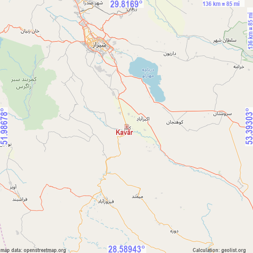
Kavār GPS coordinates[2]
29° 12' 18" North, 52° 41' 23.64" East
| Map corner | latitude | longitude |
|---|---|---|
| Upper-left | 29.8169°, | 51.98678° |
| Center: | 29.205°, | 52.6899° |
| Lower-right: | 28.58943°, | 53.39303° |
| Map W x H: | 136.5×136.5 km | = 84.8×84.8mi |
| max Lat: | 39.6482° ⇑87.3% North |
| Kavār: | 29.205° |
| min Lat: | ⇓12.7% South 25.2919° |
| min Long | Kavār | max Long |
| 44.38416° | 52.6899° | 61.9965° |
| W 63.3%⇐ | ⇒36.7% E |
Elevation
Elevation of Kavār is 1555 m = 5102 ft, and this is 506 m = 1660 ft above average elevation for this country.
| Max E: |
2564 m = 8412 ft | 26.3% |
| Kavār | 1555 m 5102 ft | |
| Avg. | 1049 m = 3442 ft | |
Min E: |
-24 m = -79 ft | 73.7% |
See also: Iran elevation on elevation.city.
Geographical zone
Kavār is located in North temperate zone (between Tropic of Cancer and the Arctic Circle). Distance of this Northern Tropic circle is 641.4 km =398.5 mi to South.| Distance of | km | miles | from Kavār |
|---|---|---|---|
| North Pole | 6759.8 | 4200.3 | to North |
| Arctic Circle | 4153.9 | 2581.1 | to North |
| Tropic Cancer | 641.4 | 398.5 | to South |
| Equator | 3247.3 | 2017.8 | to South |


Nearby cities:
15 places around Kavār: (largest is in red/bold)
• Akbarābād
9.8 km =6.1 mi,  62°
62°
• Arsanjān
98.8 km =61.4 mi,  37°
37°
• Estahbān
131.6 km =81.8 mi,  93°
93°
• Farāshband
69 km =42.9 mi,  237°
237°
• Fasā
97.7 km =60.7 mi,  107°
107°
• Fīrūzābād
41.8 km =26 mi,  196°
196°
• Jahrom
115.5 km =71.8 mi,  132°
132°
• Kherāmeh
68.6 km =42.6 mi, 61°
• Kāzerūn
110.4 km =68.6 mi,  294°
294°
• Marvdasht
75.2 km =46.7 mi,  8°
8°
• Pāsārgād
120.5 km =74.9 mi,  23°
23°
• Qīr
87.1 km =54.1 mi,  157°
157°
• Sarvestān
52 km =32.3 mi,  81°
81°
• Sa‘ādat Shahr
106.3 km =66.1 mi, 23°
• Shiraz
47.6 km =29.6 mi,  341°
341°
Sources, notices
• [Note1] Compared only with cities in Iran existing in our database
• [Src1] Map data: © OpenStreetMap contributors (CC-BY-SA)
• [Src2] Other city data from geonames.org with taken over terms of usage.
• [Src3] Geographical zone / Annual Mean Temperature by Robert A. Rohde @ Wikipedia
