Kāzerūn geodata
Kāzerūn (Fars) is a seat of a second-order administrative division; located in Iran in Asia/Tehran (GMT+3.5) time zone. With population of 94,511 people, there are 73 cities with bigger population in this country. Compared to other cities in Iran, 84.4% of cities are located further ↑North; 56.7% of cities are located further ←West and 65.5% of cities have higher elevation than Kāzerūn. Note1


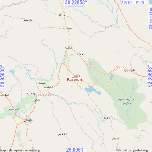
Kāzerūn GPS coordinates[2]
29° 37' 9.084" North, 51° 39' 12.6" East
| Map corner | latitude | longitude |
|---|---|---|
| Upper-left | 30.22858°, | 50.95038° |
| Center: | 29.61919°, | 51.6535° |
| Lower-right: | 29.0061°, | 52.35663° |
| Map W x H: | 135.9×135.9 km | = 84.4×84.4mi |
| max Lat: | 39.6482° ⇑84.4% North |
| Kāzerūn: | 29.61919° |
| min Lat: | ⇓15.6% South 25.2919° |
| min Long | Kāzerūn | max Long |
| 44.38416° | 51.6535° | 61.9965° |
| W 56.7%⇐ | ⇒43.3% E |
Elevation
Elevation of Kāzerūn is 847 m = 2779 ft, and this is 202 m = 663 ft below average elevation for this country.
| Max E: |
2564 m = 8412 ft | 65.5% |
| Avg. | 1049 m = 3442 ft | |
| Kāzerūn | 847 m = 2779 ft | |
Min E: |
-24 m = -79 ft | 34.5% |
See also: Kāzerūn elevation on elevation.city.
Geographical zone
Kāzerūn is located in North temperate zone (between Tropic of Cancer and the Arctic Circle). Distance of this Northern Tropic circle is 687.4 km =427.1 mi to South.| Distance of | km | miles | from Kāzerūn |
|---|---|---|---|
| North Pole | 6713.7 | 4171.7 | to North |
| Arctic Circle | 4107.8 | 2552.5 | to North |
| Tropic Cancer | 687.4 | 427.1 | to South |
| Equator | 3293.3 | 2046.4 | to South |


Nearby cities:
15 places around Kāzerūn: (largest is in red/bold)
• Ahram
89.8 km =55.8 mi,  204°
204°
• Akbarābād
116.6 km =72.5 mi,  110°
110°
• Bandar-e Genāveh
110 km =68.4 mi,  267°
267°
• Borāzjān
57.3 km =35.6 mi,  227°
227°
• Bushehr
107.3 km =66.7 mi, 227°
• Bāsht
95.3 km =59.2 mi,  329°
329°
• Dogonbadan
116.4 km =72.3 mi,  314°
314°
• Farāshband
93.4 km =58 mi,  152°
152°
• Kavār
110.4 km =68.6 mi, 114°
• Khowrmūj
110.5 km =68.7 mi,  193°
193°
• Marvdasht
114.5 km =71.1 mi,  75°
75°
• Maşīrī
70.8 km =44 mi,  349°
349°
• Nūrābād
56.5 km =35.1 mi, 346°
• Sepīdān
78.1 km =48.5 mi,  24°
24°
• Shiraz
84.8 km =52.7 mi,  90°
90°
Sources, notices
• [Note1] Compared only with cities in Iran existing in our database
• [Src1] Map data: © OpenStreetMap contributors (CC-BY-SA)
• [Src2] Other city data from geonames.org with taken over terms of usage.
• [Src3] Geographical zone / Annual Mean Temperature by Robert A. Rohde @ Wikipedia
