Fīrūzābād geodata
Fīrūzābād (Fars) is a seat of a second-order administrative division; located in Iran in Asia/Tehran (GMT+3.5) time zone. With population of 66,558 people, there are 100 cities with bigger population in this country. Compared to other cities in Iran, 89.6% of cities are located further ↑North; 62.1% of cities are located further ←West and 60.1% of cities have lower elevation than Fīrūzābād. Note1


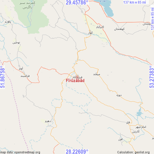
Fīrūzābād GPS coordinates[2]
28° 50' 37.68" North, 52° 34' 14.52" East
| Map corner | latitude | longitude |
|---|---|---|
| Upper-left | 29.45786°, | 51.86758° |
| Center: | 28.8438°, | 52.5707° |
| Lower-right: | 28.22609°, | 53.27383° |
| Map W x H: | 137×137 km | = 85.1×85.1mi |
| max Lat: | 39.6482° ⇑89.6% North |
| Fīrūzābād: | 28.8438° |
| min Lat: | ⇓10.4% South 25.2919° |
| min Long | Fīrūzābād | max Long |
| 44.38416° | 52.5707° | 61.9965° |
| W 62.1%⇐ | ⇒37.9% E |
Elevation
Elevation of Fīrūzābād is 1330 m = 4364 ft, and this is 281 m = 922 ft above average elevation for this country.
| Max E: |
2564 m = 8412 ft | 39.9% |
| Fīrūzābād | 1330 m 4364 ft | |
| Avg. | 1049 m = 3442 ft | |
Min E: |
-24 m = -79 ft | 60.1% |
See also: Fīrūzābād elevation on elevation.city.
Geographical zone
Fīrūzābād is located in North temperate zone (between Tropic of Cancer and the Arctic Circle). Distance of this Northern Tropic circle is 601.2 km =373.6 mi to South.| Distance of | km | miles | from Fīrūzābād |
|---|---|---|---|
| North Pole | 6799.9 | 4225.3 | to North |
| Arctic Circle | 4194 | 2606 | to North |
| Tropic Cancer | 601.2 | 373.6 | to South |
| Equator | 3207.1 | 1992.8 | to South |


Nearby cities:
15 places around Fīrūzābād: (largest is in red/bold)
• Ahram
126.3 km =78.5 mi,  271°
271°
• Akbarābād
49.1 km =30.5 mi,  24°
24°
• Farāshband
46.8 km =29.1 mi, 273°
• Fasā
105.4 km =65.5 mi,  84°
84°
• Jahrom
103.9 km =64.6 mi,  111°
111°
• Jam
115.5 km =71.8 mi,  192°
192°
• Kangān
122.8 km =76.3 mi,  203°
203°
• Kavār
41.8 km =26 mi, 16°
• Kherāmeh
102.4 km =63.6 mi,  44°
44°
• Khowrmūj
118 km =73.3 mi,  259°
259°
• Kāzerūn
123.9 km =77 mi,  314°
314°
• Marvdasht
116.8 km =72.6 mi,  11°
11°
• Qīr
60.5 km =37.6 mi,  131°
131°
• Sarvestān
79.2 km =49.2 mi,  52°
52°
• Shiraz
85.3 km =53 mi,  357°
357°
Sources, notices
• [Note1] Compared only with cities in Iran existing in our database
• [Src1] Map data: © OpenStreetMap contributors (CC-BY-SA)
• [Src2] Other city data from geonames.org with taken over terms of usage.
• [Src3] Geographical zone / Annual Mean Temperature by Robert A. Rohde @ Wikipedia
