Sepīdān geodata
Sepīdān (Fars) is a seat of a second-order administrative division; located in Iran in Asia/Tehran (GMT+3.5) time zone. In our database, there are 232 cities with bigger population. Compared to other cities in Iran, 81.4% of cities are located further ↑North; 58.7% of cities are located further ←West and 98% of cities have lower elevation than Sepīdān. Note1


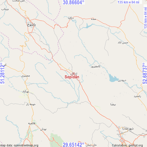
Sepīdān GPS coordinates[2]
30° 15' 38.196" North, 51° 59' 3.264" East
| Map corner | latitude | longitude |
|---|---|---|
| Upper-left | 30.86604°, | 51.28112° |
| Center: | 30.26061°, | 51.98424° |
| Lower-right: | 29.65142°, | 52.68737° |
| Map W x H: | 135.1×135.1 km | = 83.9×83.9mi |
| max Lat: | 39.6482° ⇑81.4% North |
| Sepīdān: | 30.26061° |
| min Lat: | ⇓18.6% South 25.2919° |
| min Long | Sepīdān | max Long |
| 44.38416° | 51.98424° | 61.9965° |
| W 58.7%⇐ | ⇒41.3% E |
Elevation
Elevation of Sepīdān is 2233 m = 7326 ft, and this is 1184 m = 3885 ft above average elevation for this country.
| Max E: |
2564 m = 8412 ft | 2% |
| Sepīdān | 2233 m 7326 ft | |
| Avg. | 1049 m = 3442 ft | |
Min E: |
-24 m = -79 ft | 98% |
See also: Iran elevation on elevation.city.
Geographical zone
Sepīdān is located in North temperate zone (between Tropic of Cancer and the Arctic Circle). Distance of this Northern Tropic circle is 758.7 km =471.4 mi to South.| Distance of | km | miles | from Sepīdān |
|---|---|---|---|
| North Pole | 6642.4 | 4127.4 | to North |
| Arctic Circle | 4036.5 | 2508.2 | to North |
| Tropic Cancer | 758.7 | 471.4 | to South |
| Equator | 3364.7 | 2090.7 | to South |


Nearby cities:
15 places around Sepīdān: (largest is in red/bold)
• Borāzjān
132.6 km =82.4 mi,  213°
213°
• Bāsht
80.2 km =49.8 mi,  278°
278°
• Dogonbadan
114.4 km =71.1 mi, 275°
• Eqlīd
98.4 km =61.1 mi,  43°
43°
• Kāzerūn
78.1 km =48.5 mi,  204°
204°
• Marvdasht
89.7 km =55.7 mi,  118°
118°
• Maşīrī
44.4 km =27.6 mi,  267°
267°
• Nūrābād
47.3 km =29.4 mi,  249°
249°
• Pāsārgād
115.1 km =71.5 mi,  93°
93°
• Sa‘ādat Shahr
112.4 km =69.8 mi,  100°
100°
• Shiraz
89.5 km =55.6 mi,  143°
143°
• Sīsakht
84 km =52.2 mi,  322°
322°
• Yasuj
59.1 km =36.7 mi, 320°
• Ābādeh
118.6 km =73.7 mi,  32°
32°
• Şafāshahr
122.5 km =76.1 mi,  71°
71°
Sources, notices
• [Note1] Compared only with cities in Iran existing in our database
• [Src1] Map data: © OpenStreetMap contributors (CC-BY-SA)
• [Src2] Other city data from geonames.org with taken over terms of usage.
• [Src3] Geographical zone / Annual Mean Temperature by Robert A. Rohde @ Wikipedia
